Approved Project Application: House Crayne by Zsomiking & AlexIsTragic

Emoticone11

The Dark Lord Sauron
Staff member
Hey Alex,

These tests look absolutely gorgeous; I'm in love!

The only concern that I have is that the future of the "inner Vale" as a whole (i.e., the region stretching from the Vale of Arryn to Newkeep) is sort of in a bind right now considering the news of the 1.18 height limit increase and the impact it'll have on terraforming. I'm wondering if you have any thoughts about how this might impact Crayne. Do you see a way to work on the project now without getting screwed over by the height limit increase in the future? I don't want to be a damper on things but just want to avoid a scenario where significant parts of the project need to be revised again when the new terra is done.
 

AlexIsTragic

Poet
Pronouns
they/them
The Crayne valley is relatively wide (it's one of the larger individual valleys in the inner vale), so I'd think it probably wouldn't be massively affected. It's hard for me to say right now, but unless there are large spurs I think there's enough space for a project. If most of the project is concentrated around the center of the valley, I think it'd also help with leaving some space for the terra. Additionally, I could also only terraform the bottoms of the mountain and leave the tips as is.
 

AerioOndos

Donkey Lord
Staff member
Pronouns
they/them
To update some projects' mountains we've edited the upper stony parts before. Parren-Clegane and Vikary-Marbrand and I think some around Stackspear as well. Regardless, it should be fine to finish off the mountains in retrospect as there'll be room on the other side of the slopes to make sure they look realistic.
The house tests look fantastic and I want to approve on the base of them alone.


Now, with the project, I do believe that it might look better for the stream to empty near Hearts Home, rather than into Old oak. If this was done, you could have a lower valley floor and so more room for tall trees, waterfalls and other details that would help make the project feel like a living, deep mountain valley. The current passage from Crayne to Iron Oaks could then be changed into a high pass, giving Crayne the crucial role of holding the connection between the Vale proper and the other powerful lords in the valleys directly north of them.
What do you think about that idea? It's a restructure but not too heavy, since both passages are currently lowpoints in the surrounding mountains.
 

AlexIsTragic

Poet
Pronouns
they/them
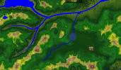
Me and Aeks have talked about his ideas for the valley, and we've decided that things might need to be be arranged differently. I've tried to roughly represent this here.
Naamloos.png

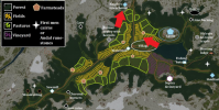
The stream will empty out in Corbray lands, and the central lake will be moved more towards the eastern part of the valley. The hill at /warp crayneruins would obviously not be there anymore. crayne map 2.png

Here's the original map for reference. The central lake would thus be moved to the eastern part of the valley, which would entail the builds that were planned in the area to be moved more towards the west. The main village and all the surrounding agriculture would be on the other side of the castle. In the case of the watermill, this would probably just mean moving it more upstream. The towerhouse's main function could be defending a mountain pass alongside the stream.
 

Emoticone11

The Dark Lord Sauron
Staff member
I think I can see a way forward with this project without being majorly affected by the height limit increase, since like you mentioned it happens to be in a fairly isolated and wide valley. The main thing to consider is that the entire valley might be raised upwards in the future in order to make a higher altitude base elevation for that part of the vale and allow for higher prominence mountains in the Vale of Arryn to the south. This shouldn't affect the flat parts of the valley since it's just a constant height shift, but it may affect the hydrology of the surrounding regions as the rivers would eventually need to meet sea level.

Could you sketch out on the topographic map where you think the "buffer zone" should be, i.e., the edges of your terraforming that will be left unfinished in order to allow blending with later terra after the height change?
 

AlexIsTragic

Poet
Pronouns
they/them
I think I can see a way forward with this project without being majorly affected by the height limit increase, since like you mentioned it happens to be in a fairly isolated and wide valley. The main thing to consider is that the entire valley might be raised upwards in the future in order to make a higher altitude base elevation for that part of the vale and allow for higher prominence mountains in the Vale of Arryn to the south. This shouldn't affect the flat parts of the valley since it's just a constant height shift, but it may affect the hydrology of the surrounding regions as the rivers would eventually need to meet sea level.

Could you sketch out on the topographic map where you think the "buffer zone" should be, i.e., the edges of your terraforming that will be left unfinished in order to allow blending with later terra after the height change?
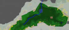
map 2.5.png
I tried to sketch it out here. The grey line would be were the terra roughly would stop, and the light grey represents the area that would be left untouched. Keep in mind that it might be 100 % accurate, as I didnt know what areas might crossover into other projects. I tried to mostly avoid any peaks or more elevated areas though.
 

Emoticone11

The Dark Lord Sauron
Staff member
I think that seems reasonable. Only thing I'd change is adding a little more of a buffer along the part where the river exits the valley.

Also, I wouldn't mind seeing the style of chalet houses in the original app used in more rural/high-altitude parts of the project, as a way to glue over the style with the other alpine regions of the Vale (e.g. the chalet style used in Redfort).

Lastly, I'd do the terraforming of the region basically assuming that the elevation of the base valley will be raised in the future, so the flora and agriculture of the valley should largely reflect alpine meadows.

Otherwise you have my re-approval!
 

Jakethesnake8_8

Firemage
Pronouns
he/him
Hi Alex, just had an idea terrain-wise. You could have the Crayne valley be a hanging valley of the larger glacial fjord that Heart's Home is situated in. A hanging valley occurs when a smaller glacier converges onto a larger one. The smaller glacier hasn't carved a deep enough path for a smooth transition, so there's a disparity in height level between the main glacial valley and the hanging valley.


This would just be an interesting way to back-up the formation of the mountains of the moon and the fingers.
 

Jakethesnake8_8

Firemage
Pronouns
he/him
Heya,
Aeks has asked us editors to try and pitch in with Crayne wherever possible, and while I can't provide direct instruction for the time being, I figured I could at the very least give my thoughts on the hydrology of the valley.

So for Crayne, my thoughts are have the area that's being worked on due to the height restrictions be harder, polished rock, and having softer rock be on the peaks to create a mountain profile seen in lots of glacial valleys. The peaks would be left for a later time, but the denser rock areas can be worked on. So the gullies wouldn't be very defined, and might be a bit sparse like these images below. They would be steep-sided, and smooth with forests creeping up them.

https://images.app.goo.gl/jmSiczvQKXvFemnNA

https://images.app.goo.gl/UjSu2eGdELCq5E176

Creating something similar to that will help transition into the fingers as well, which are most likely fjords.

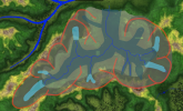
I've done a quick rough sketch of current glaciers at Crayne, former glaciers, current rivers and rock types.
Screenshot 2022-08-12 at 17.34.40.png
So the light blue would be current glaciers, remnants of larger glacial cover in the area. These would be in the higher parts of Crayne, in the soft, rocky peaks, so they would be a concern after the jump to 1.18 when we get the height to make a lot of this work. The soft rock area is denoted by the dark gray at higher elevations, and the harder rock is the lighter grey at lower elevations. The darker blue that follows on from many of the glaciers indicates historical ice cover, and how it's left behind U-shaped valleys which have been polished and smoothed by abrasion. The blue squiggles are (obviously) waterways, with most of them coming from snowmelt and glaciers.

At the lower levels, with the softer rock, the ridges would be rounded and wide, whereas they'd become more ridge-like at higher elevations as the rock type changes.

Hope this helps, and I wish you all the best!

- Jake
 

AerioOndos

Donkey Lord
Staff member
Pronouns
they/them
The current plan is for the castle mount to be part of a watershed between the Heartshome-ward bound stream and the waynwoodbound stream. That'd mean we don't need to try and fit a lot of height into the area of the ironoaks septry
 
  • Like
Reactions: FD001__

Jakethesnake8_8

Firemage
Pronouns
he/him
The current plan is for the castle mount to be part of a watershed between the Heartshome-ward bound stream and the waynwoodbound stream. That'd mean we don't need to try and fit a lot of height into the area of the ironoaks septry
Hmmm, I understand what you're going for I think, but the height of the dividing ridge is wayyy too low for the surrounding terrain, and I think it honestly makes more sense to keep the valley going one direction, instead of separating it into watersheds.
 

AerioOndos

Donkey Lord
Staff member
Pronouns
they/them
There's also not too much room for a watershed between Waynwood and Crayne. Alex, what are your feelings on the matter? With the work I've done so far on terrain, its easily changeable to a singular direction and the pass between Vale proper and Crayne idea wouldn't be removed by any large charge like that
 
  • Like
Reactions: Jakethesnake8_8