Approved Northern Reach Megabuild "Springhamshire" (Tumbleton, Risley, Smithyton)

Luk

Gullible
Staff member
Pronouns
he/him

Northern Reach Megabuild​

by Luk

I'm applying to redo both Risley and Smithyton, which both are abandoned. Clause C of the No-Redo-Rule applies in this case.
c) Abandoned Build Clause: If a build is incomplete and filed under the project orphanage as an abandoned build, it may be allowed to be redone. The intuition behind this clause is that it can be difficult to pick up someone else's outdated work, and if we expect people to do this very few people would want to apply to finish abandoned builds. However, moderators reserve the right to veto a redo for an abandoned build if they deem the existing portions to be particularly high quality.
North-Reach Megabuild.png

Overview​

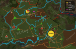
The Megabuild will consist of three projects in total: Tumbleton (already in progress), Risley, and Smithyton.
The region will be continuing the new style established at Tumbleton.
To see the house style in action, you can go to /warp statham or see the (in progress) style guide near /warp tt

House style.jpg

Goals​

  • To ensure a cohesive style across the region
  • To create consistent terraforming (i'm thinking rivers especially)
  • To fill the big unfinished gap between the reach and crownlands
  • To give people opportunities to apply for mini projects
  • To ensure consistent plotting of roads and villages without weird transitions between projects

How to contribute​

Builders will be able to apply for minis; that could be hamlets, septries or holdfasts.
There might also be additional special builds (e.g. a farm complex, a mine, etc.) which aren't planned beforehand.
Of course, every builder can contribute by building individual houses as always.
The castles/towns will not be open for testing, those will either be done by myself or delegated to an experienced builder.

Regarding Mini Applications, keep in mind:
The application is judged by quality, not by first-come first-serve.

Approval Process​

Tumbleton is already approved by Elduwin and Ramen.
I would appreciate your guys renewed approval for these plans, but i would prefer to get the opinion of a third approving mod too.
 

DutchGuard

Shadowbinder
Staff member
Pronouns
he/him
Looks great Luk!
I had the thought myself when I marked Risley as abandoned if you might be interested in taking it on. There isn't much there to redo, but I am wondering what plans you might have for what exists at Smithyton, just so we can note it here for posterity.

I'm glad you also decided to include the hill in Inchfield which hitherto was left empty. It would be great if you could somehow tie a mini there into the extant context; I can see you've marked the Inchfield septry nearby which is a good sign of your intentions for the area.

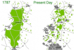
Also wanted to quickly point out that the seat of House Risley has a proper name: Risley Glade. I don't know if this should necessarily play too much of a role, as it's probable that much of the forest surrounding the castle has long since been cut down. I quite like the idea of this whole area having once been part of the ancient Kingswood, with only a few pockets left here and there (as indicated on your map). This is similar to ancient woodland in England where once large forests have been reduced and divided into much smaller pockets. Below is Sherwood Forest, as an example of that phenomenon.

1614190618370.png
 

Luk

Gullible
Staff member
Pronouns
he/him
Thanks for the input, dutch!

For Smithyton, i would actually redo the town, but keeping a very similar theme.
I really like the idea of the town and castle, and would like to keep that look.
Especially the castle, i think i'll just update it.

Indeed i included the empty hill in Inchfield in my plans too (forgot to mention that).
I won't touch anything else in Inchfield, just want to tie everything together and fill all the gaps.
I'm thought a holdfast would fit perfectly on that hill.

Also great idea regarding the evolution of the forests in the region! :)
 

Luk

Gullible
Staff member
Pronouns
he/him
Update:

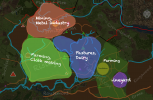
On request by Eld, i prepared a rough map of the different industries that will be present in the region:
  • Around Tumbleton: Pretty much only farming
  • The hill at Merkley will be a vineyard
  • Across the Footly hill, there will be a lot of pastures and dairy farms
  • Around Smithyton: A few mines, and predominately "smithy" related industries
  • Risley: The area presents perfect conditions for big fields, it's flat and fertile ground.
    There will be lots of farming again, but also facilities for cloth making, and rope making.
    I'm hoping for the hemp plant in the next update, so there will be a lot of hemp fields, providing the resources for making cloth and ropes.
Industries.png
 

Luk

Gullible
Staff member
Pronouns
he/him
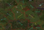
So i made a little field study...
I looked at all existing projects in the area and looked at the wind direction.

Heres the result:
The blue arrows represent the existing wind directions and the yellow arrows are what i propose as sensible wind directions for the three northern reach projects (and Orme).
Wind direction map.jpg
 

Thamus_Knoward

Shadowbinder
Update:

On request by Eld, i prepared a rough map of the different industries that will be present in the region:
  • Around Tumbleton: Pretty much only farming
  • The hill at Merkley will be a vineyard
  • Across the Footly hill, there will be a lot of pastures and dairy farms
  • Around Smithyton: A few mines, and predominately "smithy" related industries
  • Risley: The area presents perfect conditions for big fields, it's flat and fertile ground.
    There will be lots of farming again, but also facilities for cloth making, and rope making.
    I'm hoping for the hemp plant in the next update, so there will be a lot of hemp fields, providing the resources for making cloth and ropes.
View attachment 7353
Just chiming in from the sidelines here!

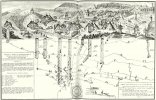
Farming would take place on lands further away from the rivers but near settlements, pasture/ dairy land would happen right by the river yet farther away from settlements, mining would also happen on or near the hills (away from the groundwater level). You might want to adjust your industries accordingly i.e. give each of the project lands a bit of everything!


EDIT: That was a gross simplification. Here's some more text and images to back it up for the curious!

 
Last edited:

Luk

Gullible
Staff member
Pronouns
he/him
Just chiming in from the sidelines here!

Farming would take place on lands further away from the rivers but near settlements, pasture/ dairy land would happen right by the river yet farther away from settlements, mining would also happen on or near the hills (away from the groundwater level). You might want to adjust your industries accordingly i.e. give each of the project lands a bit of everything!


EDIT: That was a gross simplification. Here's some more text and images to back it up for the curious!


Thanks for the input. Totally agree with you there.

The "industry map" was just to give an indication as to what indsutries are predominantly defining each region.
On the south end towards the mander, i was planning to have a "Driesch" area which is used as pastures by the locals.

The diagram you shared is a good resource! The farmlands would form around the hamlets, more towards the middle of the project.