Dornish Marches Terra

CashBanks

A Knight at the Opera
Staff member
Hey everyone,
I've been discussing with a few builders how we'd like to approach the terra of the Dornish Marches (the area to the south west of the Stormlands) and thought I should post a thread here so we can get it settled and approved once and for all. Shout out to Aeks, Endy, Sseri for the thought they've put into it so far.

Copying out some notes that Aeks has put together for his potential Vyrwel app,
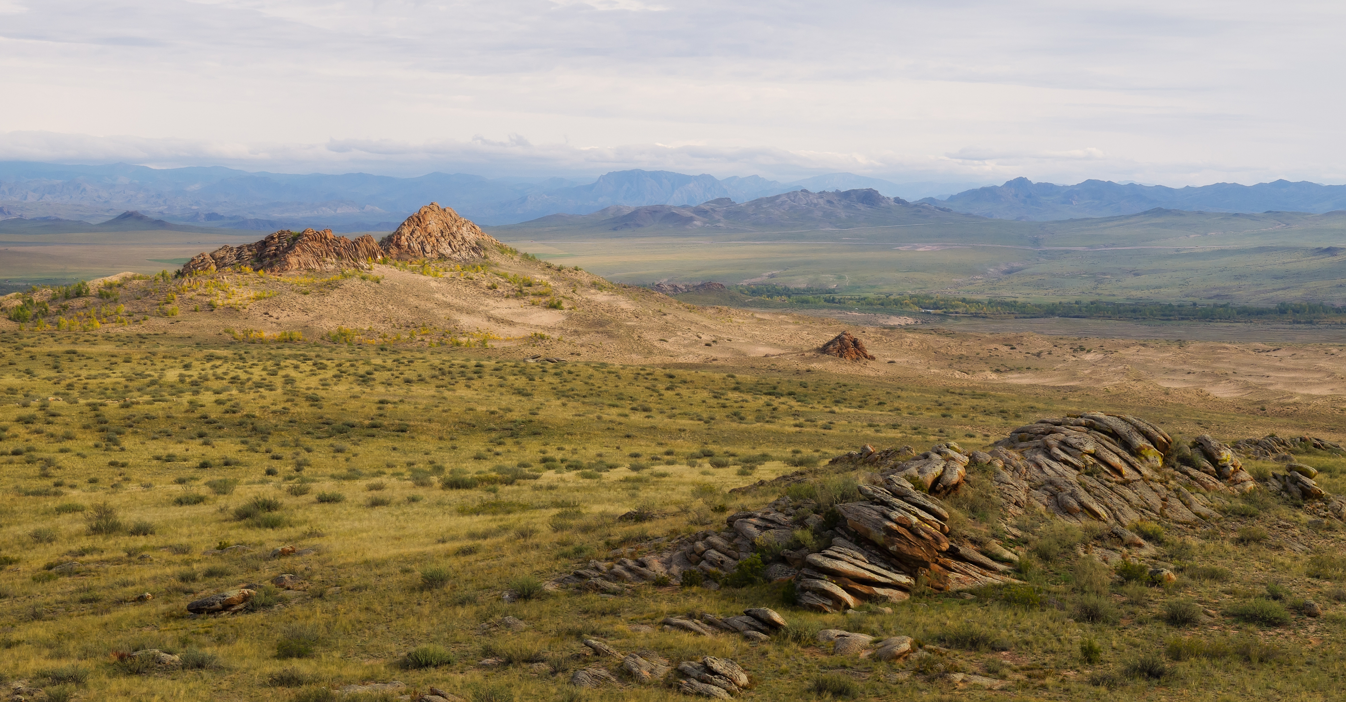
To reiterate canon, the Marches, which sit north of and around the Red Mountains, sit along the border of Dorne and its northern neighbours. They stretch from Hornhill in the west to Stonehelm in the Redwatch. While the Reach has previously held territory as far as Nightsong, nowadays most of the Marches are in the Stormlands.
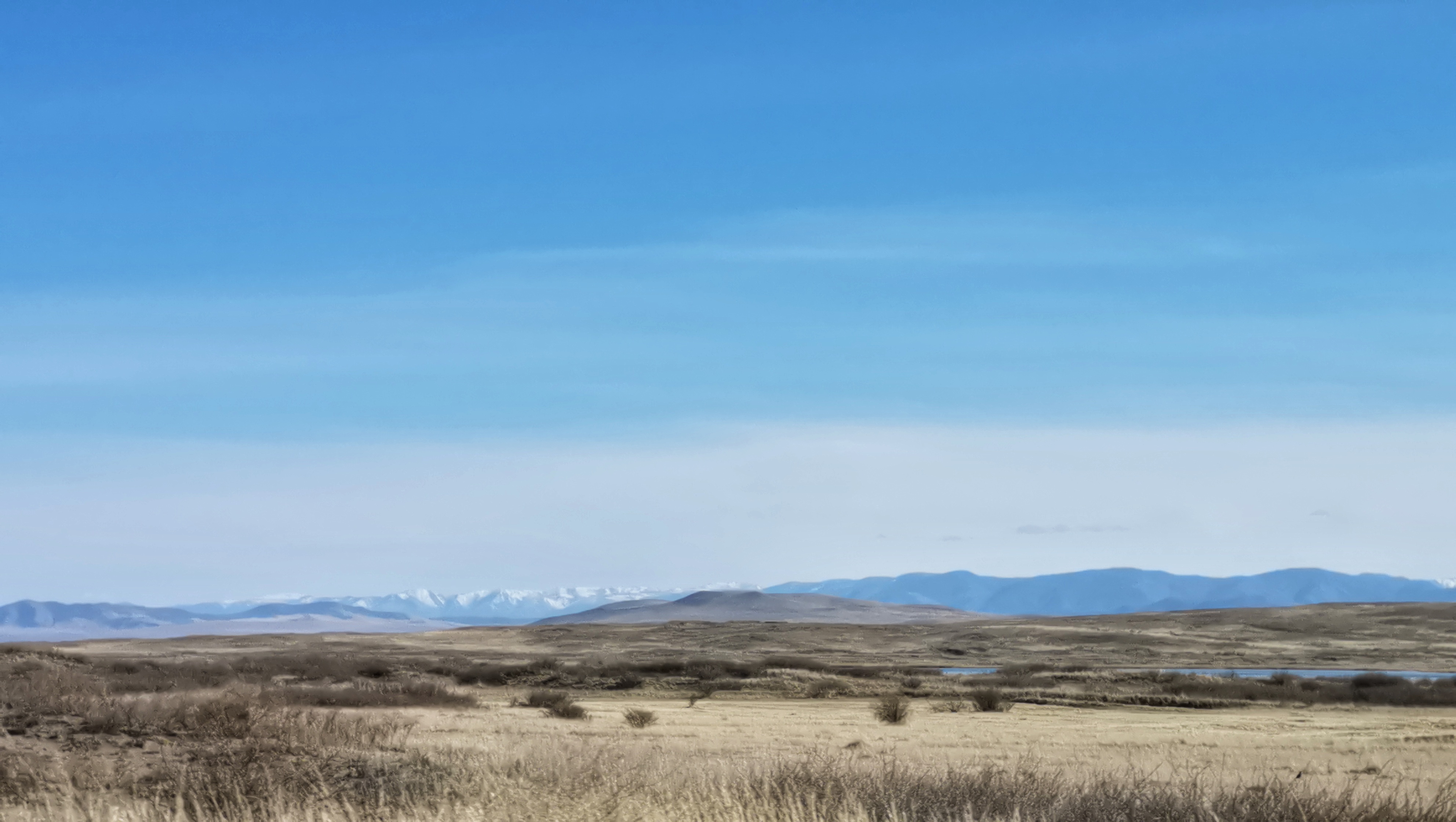
The Marches are mainly windswept grassland, moor and plain. A road runs from Summerhall in the Northern Marches to Yronwood via the Boneway.
Redwatch is an area in the southern marches where the Red Mountains join Cape Wrath. Stonehelm is here and sits above the Slayne, one of the major river routes in the Stormlands.
House Yronwood possibly laid claim to Redwatch as one of their former titles was 'Lord of the Redmarch', representing how the Marcher lords and the lords of the mountains view the area.

Aeks also proposed a breakdown of the area's biomes, with the currently abandoned or in progress section around the Princes pass to be part of a grassland area with dryer dusty raised plain separating Caron, Vyrwel, Cockshaw and Leygood from Selmy Lands.
Selmy/HarvestHall is one of the most productive regions in the marches, providing more food than most. It likely has large wheatfields and probably has tributaries of the Cockleswhent passing through it.
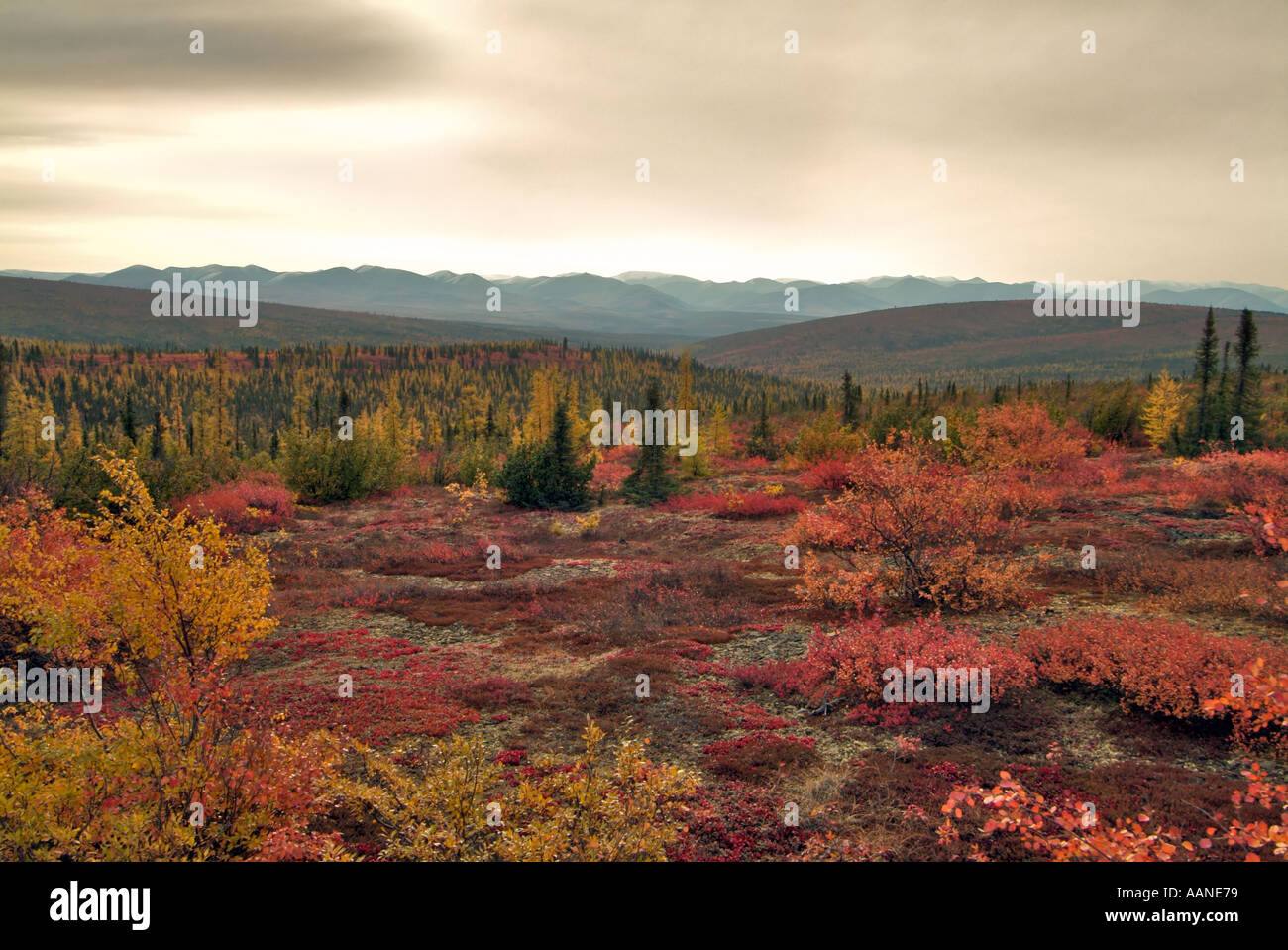
The eastern edge, Redwatch and around Summerhall would be the moor area. it will be damper than the central area as it is fed by the Slayne and its tributaries as well as from some of the rain that comes the eastern edge of the Red Mountains from Cape Wrath.

Sseri has pointed out that the moorlands/grasslands could be a result of the Red Mountains creating a "rain shadow" over the areas to their west/north west. The mountains block the rain clouds, so the area on the other side is drier.
1602052402710.png

I'm more or less fine with this proposal and have already taken this approach with the terra around Summerhall, attempting to create rolling hills of moors and low grass with minimal trees.
Here's what the various biome options look in game:
1602043772144.png

I think it's clear that it's the Mushroom, Birch and Extreme Hills biome create the most pronounced color change effect, and when mixed together they create a lighter yellow/green color that would suit the drier grasslands/moors of the Marches.
So this is my proposal for the biome mix.
1602042049956.png
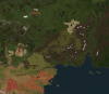
The darker area in the center/east represents the moors/grassy plains which could be achieved with a mix of Extreme Hills, Birch Forest and Mushroom biomes, while the lighter yellow is the more arable, wheat fields of Harvest Hall. The green would be a transition zone between these biomes and the Reach Plains. The area on the east side of the mountains and along the coast (Black Haven Holdfast/Swann's Roost) wouldn't be changed.

On the dynmap these biomes would look something like this when implemented (and the Harvest Hall terra is finished) Apologies for the paint color swap.
1602045553516.png

So the biomes would be:
Summerhall area #l3d[#L3d[$BirchForest,$MushroomIsland,$ExtremeHills]
Harvest Hall area #L3d[$BirchForest,$MushroomIsland]
Transition zone #L3d[$Plains,$BirchForest] + some random variation so it doesn't look completely uniform.

For those unfamilar, #l3d creates a checkerboard pattern, e.g. //set #l3d[red,blue,green] produces:
1602043926781.png
This can be used with biomes to create a super even mix between them and basically create a new shade of grass color.
#L3d[$BirchForest,$MushroomIsland,$ExtremeHills] is what i've currently got around Summerhall.

Here's the grass mix I'm proposing to use for the moors area (can see it in game around Summerhall). I've got this grass mix setup as a script.
1602044079920.png

So what I'm essentially looking for today is permission to update the biomes and grass terra in the dark yellow/green area with the checkerboard mix of Extreme Hills/Birch/Mushroom, (I'll leave Harvest Hall to Iwan and Iwan's children and Iwan's children's children). Musgood has been inactive for quite a while now, but HG_Kool_Aid_Man was on board with these ideas when I sketched them out with my initial Summerhall app. I also included the Gallows Grey foster as part of my Summerhall app so I figure it should fall under that purview. Aeks has also suggested we trim down the northern parts of the Red Mountains a bit to make them grow a bit more gradually and create some more foothills.

Veggie and thecoddfish as my approving mods maybe you're in the best position to give sign off, but will listen to any other productive suggestions.


1602044978131.png
 

Attachments

  • 1602042292493.png
    1602042292493.png
    1.1 MB · Views: 2
Last edited:

thecoddfish

Emissary
Staff member
One thing I'd like to see addressed is how the "checkerboard" of individual biomes will influence the appearance of certain blocks within the region - i.e. stone blocks that vary their colour depending on biome.

Otherwise I also quite like the birch forest and extreme hills tests, but it's hard to get a sense for their appearance on a larger scale. Would you be able to put together some tests of these biomes in the production world, perhaps in the areas you've been working on near Summerhall, and post the screenshots?
 

Ramen

Faith Militant
As far as I've been able to tell the only building materials that get significantly affected by changing biomes are greyscale blocks, which would be unlikely to cause issues in the region because of its palette.
 
  • Like
Reactions: SseriousBusiness

AerioOndos

Donkey Lord
Staff member
Pronouns
they/them
*my album* Sorry, it isn't good enough to be one of Sseri's.

Another point, it would be good to make some more tight higher passes between Trant and Dondarrion rather than a little river and lake system that disrupts the rainshadow
 

Margaery_Tyrell

The Dark Lord Sauron
I'm not sure I understand why the section of the marches between the moist and rainy Stormlands and the lush and temperate Eastern Reach is supposed to be dry? Id also recommend extending the transition zones A LOT more, its too stark of a change from moist to dry
 
  • Haha
Reactions: Adorkabley

CashBanks

A Knight at the Opera
Staff member
Those transitions zones will just be between the Reach and the Marches area of the Stormlands, which aren’t moist and rainy. The transition between the wet/stormy Stormlands and the Reach will be as you imagine.

Here's a comparison of the various biomes. I'm thinking the mix of all three still works best to make it look mottled and dry.
As Ramen mentioned I think we'll be fine with any potential block shadings since it's really just stone and water blocks that have the most pronounced effect, and we can give any areas of water their own specific biome for the appropriate color.
 

AerioOndos

Donkey Lord
Staff member
Pronouns
they/them
The only description of the Cockleswhent, one of two river systems that will pass through the marches, is from Dunk and Egg. And grasslands do not have to be dry, only 'drier' than the temperate rainforest of Cape Wrath.

I'd say that between the Red Mountains and the Cockleswhent, once over the rocky divide near what is currently Leygood, it becomes lush grassland with maybe a few stands of trees, these clusters of trees increasing in number in proximity to the river.
Arable, not dry
At the particular area there, east of Ashford and in which Ashford Meadow canonically sits, the marches should be considerably more like an open grassland, than moor.
I can see the images that I used for insp but they are across multiple devices atm. And there was a Insta story of an influencer staying in Southern France which was just perfect. and I didn't screenshot :c
 
It's reminds me a bit of the Canadian Artic Tundra in the summer because of the purple-red hues.

tundra-in-autumn-at-the-arctic-circle-dempster-highway-yukon-canada-AANE79.jpg

mountains-2731249_960_720.jpg
 

Margaery_Tyrell

The Dark Lord Sauron
Those transitions zones will just be between the Reach and the Marches area of the Stormlands, which aren’t moist and rainy. The transition between the wet/stormy Stormlands and the Reach will be as you imagine.

Here's a comparison of the various biomes. I'm thinking the mix of all three still works best to make it look mottled and dry.
As Ramen mentioned I think we'll be fine with any potential block shadings since it's really just stone and water blocks that have the most pronounced effect, and we can give any areas of water their own specific biome for the appropriate color.

The only description of the Cockleswhent, one of two river systems that will pass through the marches, is from Dunk and Egg. And grasslands do not have to be dry, only 'drier' than the temperate rainforest of Cape Wrath.

I'd say that between the Red Mountains and the Cockleswhent, once over the rocky divide near what is currently Leygood, it becomes lush grassland with maybe a few stands of trees, these clusters of trees increasing in number in proximity to the river.
Arable, not dry
At the particular area there, east of Ashford and in which Ashford Meadow canonically sits, the marches should be considerably more like an open grassland, than moor.
I can see the images that I used for insp but they are across multiple devices atm. And there was a Insta story of an influencer staying in Southern France which was just perfect. and I didn't screenshot :c

I'm not sure that either of these answers my question of *why* a dry zone exists between two moist zones just of *how* you're going to accomplish your proposed dry moors, typically higher elevations are *sources* or accumulators of moisture from prevailing winds or snowmelt, a rain shadow creates a lack of moisture not on mountains, but on the lands behind the rain shadow, which neither the lush Reach or rainy Stormlands possess.

I understand that the canon says "moors" but your depiction of moorlands (especially heath moorlands) aren't ecologically feasible since heather moorlands exclusively happen in the northern expanses of the UK islands especially in cold climates. Furthermore the vast majority of naturally established heather moorlands (i.e. not created or introduced by human activity) exist pretty exclusively in the far north, with southern heather moorlands being introduced by human activity especially deforestation (such as the Pennine moorland).

Heather-coverage-UK.png

That being said, the Dornish marches as you two are proposing looks nothing like any conventional form of moorland or southern france scrubland, but more like the Eurasian Steppe or Mongolian Steppe.

%D0%A2%D1%83%D0%B2%D0%B8%D0%BD%D1%81%D0%BA%D0%B8%D0%B5_%D0%BF%D1%80%D0%BE%D1%81%D1%82%D0%BE%D1%80%D1%8B.jpg

Dus-Khol_lake_outskirts.jpg

It doesn't even look like any conventional moorland found in other European climates:

Titel.jpeg
WeisserStein_Steg.jpg
Fagne_Tirifaye_with_the_Hill_river_in_Waimes%2C_Belgium_%28DSCF3682%29.jpg

I'm also having difficulty with another proposal of yours, to extend this dry region into the Red Mountains where canonically the valleys are supposed be lush with sweet green grass, crisp cold air in the meadows of Yronwood and having extensive sources of lumber and Skyreach having enough runoff from the mountains to have plentiful game.

This proposal honestly lacks a lot of cohesion and feels like a massive abrupt transition from wet to dry and wet again for the sake of having this hybrid Dry Eurasian Steppe with Northern Scottish Heather Moorlands characteristics. I highly recommend you do a little bit more research and try to make the ecology make more sense and create larger zones of transition from one ecological zone to the next.
 
Last edited:

Ramen

Faith Militant
I'm not sure that either of these answers my question of *why* a dry zone exists between two moist zones just of *how* you're going to accomplish your proposed dry moors, typically higher elevations are *sources* or accumulators of moisture from prevailing winds or snowmelt, a rain shadow creates a lack of moisture not on mountains, but on the lands behind the rain shadow, which neither the lush Reach or rainy Stormlands possess.

I understand that the canon says "moors" but your depiction of moorlands (especially heath moorlands) aren't ecologically feasible since heather moorlands exclusively happen in the northern expanses of the UK islands especially in cold climates. Furthermore the vast majority of naturally established heather moorlands (i.e. not created or introduced by human activity) exist pretty exclusively in the far north, with southern heather moorlands being introduced by human activity especially deforestation (such as the Pennine moorland).
Moorlands, including heathlands aren't limited to just cold and dry climates. The heathlands in the south-west of England (Dartmoor in particular being a strong source of inspiration for this terra) have relatively warm climates and receive quite a lot of rain (even up to 70 inches/year in some areas), so would be plenty feasible in the type of climate you are suggesting the Reach/Stormlands border area would have.

I'm also having difficulty with another proposal of yours, to extend this dry region into the Red Mountains where canonically the valleys are supposed be lush with sweet green grass, crisp cold air in the meadows of Yronwood and having extensive sources of lumber and Skyreach having enough runoff from the mountains to have plentiful game.
These particular descriptions pertain to the foothills south of the Red Mountain, and the areas around the Prince's Pass. The Red Mountains along the borders of the Stormlands and Dorne are described as a landscape dominated by "deep dry valleys and great sandstone cliffs", so I feel that having a drier Spanish/Eurasian landscape in the southern parts of the proposed terra is more than warranted. That being said, I would love to see more detailed plans and a larger transition zone particularly in the southern portion, but also for the northern area as it transitions towards the Kingswood.
 

Azulejo

Bloodmage
Staff member
From my humble point of view as a non-builder I think that the biggest problem that the Dornish Marches have is its location. Both the Reach and the Stormlands are characterized by being areas with a temperate climate, and rather humid (especially the second). The Red Mountains, at the foot of which this region is situated, act (or should act), as collectors of the rains and storms that irrigate the regions to the north, thus making their northern façade more humid than the southern one. This initially would make it impossible to create an area of pastures and moors, since the greater influx of water and less insolation should facilitate the formation of forests. I believe that, unless we find a logical explanation according to which this region receives less rain, human activity should be chosen as the determining factor when creating the open spaces that characterize it. In areas with an oceanic climate, surfaces without tree cover are due to environmental degradation, caused by human activities. Maybe soil composition (or its thickness) could be used to explain why there are no trees here. High rainfall withouth tree cover would strip off the layers of dirt, exposing bedrock. GRRM has made it difficult for us:confused:
I understand that the canon says "moors" but your depiction of moorlands (especially heath moorlands) aren't ecologically feasible since heather moorlands exclusively happen in the northern expanses of the UK islands especially in cold climates. Furthermore the vast majority of naturally established heather moorlands (i.e. not created or introduced by human activity) exist pretty exclusively in the far north, with southern heather moorlands being introduced by human activity especially deforestation (such as the Pennine moorland).
I fully agree. In English "moor", although it is a term applicable to several landscapes, is often used to refer to a very specific one typical of the north of the British Isles. But it isn't limited to that. For me, heather moorlands are more typical of the North than of any of the regions south of the Neck. Quoting from wikipedia: "Generally, moor refers to highland and high rainfall zones whereas heath refers to lowland zones which are more likely to be the result of human activity."
 

Elduwin

Skinchanger
Staff member
I've tried a go on the Westeros Climate map to see what would be the local climate.
If we follow that map (which, in my opinion, is probably the best explanation on how climates work on Westeros, considering how fucked up they are compared to Earth climates (especially with latitudes)), we might end up with a riviera/hot area on all the western coast of the Sea of Dorne and up to the Dornish Marches.
What would make sense to explain that the area is dry is for the hotstreams to go as far North as the marches, and then meet cold streams coming from the far North, creating the stormy and rainy region of the Stormlands.
I don't really know what to do with that. I can't really think of real examples of rain forests so close to dry biomes, at least in Europe. But, I do wonder if moors are the right biome for that area. It might be worth looking in hotter dry biomes, considering it's still quite close to the Dornish desert in the end.
climate copie.png
 
  • Like
Reactions: Azulejo
I've tried a go on the Westeros Climate map to see what would be the local climate.
If we follow that map (which, in my opinion, is probably the best explanation on how climates work on Westeros, considering how fucked up they are compared to Earth climates (especially with latitudes)), we might end up with a riviera/hot area on all the western coast of the Sea of Dorne and up to the Dornish Marches.
What would make sense to explain that the area is dry is for the hotstreams to go as far North as the marches, and then meet cold streams coming from the far North, creating the stormy and rainy region of the Stormlands.
I don't really know what to do with that. I can't really think of real examples of rain forests so close to dry biomes, at least in Europe. But, I do wonder if moors are the right biome for that area. It might be worth looking in hotter dry biomes, considering it's still quite close to the Dornish desert in the end.
View attachment 5350
This bit of the Croatian coast might interest people because it's kind of a dry area near a relatively wet/non arrid part of the Balkans.

Capture.JPG
Capture.JPG
 

Azulejo

Bloodmage
Staff member
I don't really know what to do with that. I can't really think of real examples of rain forests so close to dry biomes, at least in Europe. But, I do wonder if moors are the right biome for that area. It might be worth looking in hotter dry biomes, considering it's still quite close to the Dornish desert in the end.
Maybe Atlas Mountains could be look into? They separate the Sahara from the wetter north of Morocco. I wouldn't look into hotter regions thought. It just doesn't make much sense having wet, temperate regions at the foothills, then drier tree-less higher up. Sistema Central or southern Cordillera Cantabrica could be used too? I think instead of looking at rainfall we should seek other factors that may create grasslands, like poor, unproductive soil or overgrazing (goats often do that)
 
  • Like
Reactions: jmcmarq

Azulejo

Bloodmage
Staff member
Dehesas could be used as a buffer zone between whatever is located at the Marches and Reach/Stormlands proper. They are man-made grazing areas with low density treecover, mostly holm and cork. They appear in low cuality soils, usually granites, but wetter regions than other mediterranean landscapes.
 

lemonbear

Nymeria
Staff member
Pronouns
she/her
These particular descriptions pertain to the foothills south of the Red Mountain, and the areas around the Prince's Pass. The Red Mountains along the borders of the Stormlands and Dorne are described as a landscape dominated by "deep dry valleys and great sandstone cliffs", so I feel that having a drier Spanish/Eurasian landscape in the southern parts of the proposed terra is more than warranted. That being said, I would love to see more detailed plans and a larger transition zone particularly in the southern portion, but also for the northern area as it transitions towards the Kingswood.

This description actually sounds a lot like the eastern California region. California has a mountain range called the Sierra Nevada (that includes Yosemite, Lake Tahoe, etc.) that more or less separates the chaparral and grasslands of the coastal regions and Central Valley from the southern desert region that includes the Mojave.

Topographic map of California:
KAPPA1663127.jpg

Biome map of California as a whole:
5915542_orig.jpg
Biome map of the Sierra Nevada region:
013f51641b31e9fabcf5b04b6149c66a.jpg

Sierra Nevada:
california-sierra-nevada-mountains-wildflowers-bloom-in-valley_u-l-q13cycb0.jpgsecret-sierra-nevada-ca-horse-packing-trip-0513.jpg
 

CashBanks

A Knight at the Opera
Staff member
Will get to a more comprehensive response later but for what it’s worth now I have no particular attachment to the use of heather if that’s the biggest point of concern.

Marg I’m not really sure how to respond to your concern about cohesion I’ve essentially just tried to follow how it’s described in the canon. The Marches are described as “a vast expanse of grasslands, moors, and windswept plains stretching westward and northward for hundreds of leagues”, so I tried to mark out a map of the Marches accordingly.

We were going with the idea that the Red Mountajns created a rain shadow over the region, since moors are supposed to be dominated by heath plants which generally grow in dry areas with acidic, low fertility soil, but if the “dry” terminology is just too difficult to rationalize then we can try a different biome mix, but at the end of the day the area will still need to be covered in grassland.

The transition zones won’t be 1:1 to what I’ve done on the map and will be wider, but we’re going to be hit with the limitation of the map scale.
 
This description actually sounds a lot like the eastern California region. California has a mountain range called the Sierra Nevada (that includes Yosemite, Lake Tahoe, etc.) that more or less separates the chaparral and grasslands of the coastal regions and Central Valley from the southern desert region that includes the Mojave.

Topographic map of California:
View attachment 5353

Biome map of California as a whole:
View attachment 5354
Biome map of the Sierra Nevada region:
View attachment 5355

Sierra Nevada:
View attachment 5356View attachment 5357
I like the second picture. Great balance and transition.