A Stormlands Overhaul

_Simbaa

Printmaker
I replied in haste to Sim, and I apologize for that. I've just read through your Wendwater ideas and I am afraid to say I am totally against them. The Kingswood is quite literally the King's wood, a private area of forest for exclusive use by the nobility. There are canonically bands of outlaws living in the area, but I would be really against any permanent settlements, unless they were associated with royal forestry or hunting.

I really like your creative ideas, but I feel very strongly that the Kingswood should be basically off limits for the foreseeable future. To be clear, the area I am talking about is highlighted in pink below, with the black line representing my best guess for the regional border.

View attachment 11497
Agreed with dutch - no settlements would mean that there would be no reason to move/overhaul Wendwater at this point, as such decision should happen alongside the eventual Kingswood project/update
 

DutchGuard

Shadowbinder
Staff member
Pronouns
he/him
Well, isn't the Kingswood itself, as legal Royal property, fully in Crownlands? In the third post I wrote quite fully why I think there should be a town here, not in the King's wood, but on the Stormlands side of the upper Wendwater, as the river is the border between Stormlands and Crownlands (and Kingswood, as such).
Does the king not rule all of Westeros? Or only the Crownlands? It is canon that the Kingswood is in both regions.
 

Nikas Kunitz

Herald
You can find more of my thoughts on the topic here, where future discussion about the Kingswood should take place.
Yeah, I read it and I found nothing to contradict with my suggestions. Again, I think the King's wood as Royal property lies fully in Crownlands, and as the border between Crownlands and Stormlands goes mostly (as such, in place we'are discussing) on Wendwater course, the part of the old "Kingswood" forest that remained in Stormlands was free of any particular restrictions on clearing and settlement.
Update, as I missed the replies when I was writing this.
[moved reposted below]
 
Last edited:

Nikas Kunitz

Herald
Does the king not rule all of Westeros? Or only the Crownlands? It is canon that the Kingswood is in both regions.
Update, devided the post in case it wasn't notified.
Yes, the monarch is suzerain of all the lands in Westeros. But as Seven Kingdoms are a feudal monarchy, the direct Royal lordship is restricted to Crownlands - this is literally why they exist, as Royal domain, immediate lands of Royal jurisdiction. The monarch effectively is lord of Crownlands, where all the lords are his direct vassals. Stormlands are outside of Royal domain, so they are legally separate state, bound to the monarchy by vassal allegiance of the lords of Storm's End, who are in turn overlords of Stormlands lords and lands.
Such particular legal restrictions on Kingswood are very unlikely to have legal power outside direct Royal domain.
As such, name Kingswood commonly (in-universe) is applied to whole "old" Kingswood, even including parts that remained in Stormlands, because, firstly, the far bigger part of old "Kingswood" became the King's wood and part of Crownlands; secondly, the parts of old "Kingswood" that remained in Stormlands are anyway natural part of the same old "Kingswood", even through not being part of the legal King's wood. Moreover, the Stormlands part of the forest is largely intact (remains forest) with the most notable exception of cleared and settled place around the town I suggested, which anyway stands on cleared Kingsroad with its bridge over Wendwater.
 

AerioOndos

Donkey Lord
Staff member
Pronouns
they/them
okay so the main issue I find with an undeveloped wendwater valley is that we’ve got the Slayne being referred to as ‘one of’ the major river trading routes. It would make sense if the wendwater was another, if only for wood ferrying.

now, it might be better to refer to the ‘old Kingswood’ as Old Forest or Old forest 1 or something, it’s the northern remnant of the ancient forest which covered westeros from cape wrath to cape kraken.
 

Azulejo

Bloodmage
Staff member
Not all of the Kingswood is part of the area dedicated to the private hunting of the kings. Also at least according to the map of A Feast of Crows the Kingswood is located north and west of the Wendwater.​
 
  • Like
Reactions: Nikas Kunitz

DutchGuard

Shadowbinder
Staff member
Pronouns
he/him
Update, devided the post in case it wasn't notified.
Yes, the monarch is suzerain of all the lands in Westeros. But as Seven Kingdoms are a feudal monarchy, the direct Royal lordship is restricted to Crownlands - this is literally why they exist, as Royal domain, immediate lands of Royal jurisdiction. The monarch effectively is lord of Crownlands, where all the lords are his direct vassals. Stormlands are outside of Royal domain, so they are legally separate state, bound to the monarchy by vassal allegiance of the lords of Storm's End, who are in turn overlords of Stormlands lords and lands.
Such particular legal restrictions on Kingswood are very unlikely to have legal power outside direct Royal domain.
As such, name Kingswood commonly (in-universe) is applied to whole "old" Kingswood, even including parts that remained in Stormlands, because, firstly, the far bigger part of old "Kingswood" became the King's wood and part of Crownlands; secondly, the parts of old "Kingswood" that remained in Stormlands are anyway natural part of the same old "Kingswood", even through not being part of the legal King's wood. Moreover, the Stormlands part of the forest is largely intact (remains forest) with the most notable exception of cleared and settled place around the town I suggested, which anyway stands on cleared Kingsroad with its bridge over Wendwater.
I think I agree with this. The problem is that the word "kingswood" is used in canon interchangeably as both the private hunting forest and the wider forest, which is where our difference in interpretation comes from.

That said, the kingswood (the whole forest) is canonically known, even during the events of ASoIaF, as a wild and dangerous place full of outlaws and huge forest fires. It doesn't sound like the kind of area anyone would want to settle down in. I think having perhaps a fortified inn at the Wendwater crossing, similar to the Inn at the Crossroads, would be more appropriate. The forest should be filled with rebel and highwaymen encampments, perhaps even some secret children of the forest stuff. I don't see the need for a town.

That said, it seems to be mostly a matter up for interpretation. Ultimately the decision should fall to whoever takes on the kingswood (the whole forest) as a project. The whole forest needs to be done as one project because the foliage should be consistent regardless of which region it is in.
 

Nikas Kunitz

Herald
I think I agree with this. The problem is that the word "kingswood" is used in canon interchangeably as both the private hunting forest and the wider forest, which is where our difference in interpretation comes from.

That said, the kingswood (the whole forest) is canonically known, even during the events of ASoIaF, as a wild and dangerous place full of outlaws and huge forest fires. It doesn't sound like the kind of area anyone would want to settle down in. I think having perhaps a fortified inn at the Wendwater crossing, similar to the Inn at the Crossroads, would be more appropriate. The forest should be filled with rebel and highwaymen encampments, perhaps even some secret children of the forest stuff. I don't see the need for a town.

That said, it seems to be mostly a matter up for interpretation. Ultimately the decision should fall to whoever takes on the kingswood (the whole forest) as a project. The whole forest needs to be done as one project because the foliage should be consistent regardless of which region it is in.
Well, I agree with Kingswood being a dangerous wild place, full of brigands and outlaws and other unpleasant pigs people. This is canon-accurate, to be sure. But Kingswood is very big even on our map, so it is even bigger on "real" Westeros. The town I proposed is located on its very edge, separated by Wendwater from Kingswood (both as private Royal property and a place full of outlaws). Taking into consideration the presence of brigands, I think the town is even more logically needed - as the very first (closest to KL) settlement on Kingsroad, where one can have safety both for self and his goods, if there are. And, as Kingsroad in Kingswood is a dangerous place, usage of Wendwater as transport route to KL is even more justified, in my opinion, in addition to the fact that transportation of goods downstream on the river is much easier than using landway. Even through robbing cargoboats on Wendwater is possible, I think it is anyway much harder than robbing cargowagons on Kingsroad, as such, transportation on Wendwater is safer.
As I wrote in posts above, main exports from [Northern] Stormlands to KL through Wendwater are various agricultural products, as evergrowing population of KL always creates demand for more and more. While quite smaller (in terms of tonnage) than exports, there are also imports to Stormlands from KL, mainly various crafted goods, like textiles, intruments and various other stuff that KL craftsmen produce in much more bigger quantities and diversed qualities than craftsmen in towns of Stormlands. Even through such goods as textiles are much easier transported by sea merchantships, the peculiar hindrances of having stable big ports on Northern Stormlands coast causes using Wendwater and Kingsroad to transport goods to inland Northern Stormlands. As such, the town I proposed also has small market where goods from KL are sold by merchants from KL and bought by merchants who distribute them among the towns and villages of Northern Stormlands.
 

DutchGuard

Shadowbinder
Staff member
Pronouns
he/him
Well, I agree with Kingswood being a dangerous wild place, full of brigands and outlaws and other unpleasant pigs people. This is canon-accurate, to be sure. But Kingswood is very big even on our map, so it is even bigger on "real" Westeros. The town I proposed is located on its very edge, separated by Wendwater from Kingswood (both as private Royal property and a place full of outlaws). Taking into consideration the presence of brigands, I think the town is even more logically needed - as the very first (closest to KL) settlement on Kingsroad, where one can have safety both for self and his goods, if there are. And, as Kingsroad in Kingswood is a dangerous place, usage of Wendwater as transport route to KL is even more justified, in my opinion, in addition to the fact that transportation of goods downstream on the river is much easier than using landway. Even through robbing cargoboats on Wendwater is possible, I think it is anyway much harder than robbing cargowagons on Kingsroad, as such, transportation on Wendwater is safer.
As I wrote in posts above, main exports from [Northern] Stormlands to KL through Wendwater are various agricultural products, as evergrowing population of KL always creates demand for more and more. While quite smaller (in terms of tonnage) than exports, there are also imports to Stormlands from KL, mainly various crafted goods, like textiles, intruments and various other stuff that KL craftsmen produce in much more bigger quantities and diversed qualities than craftsmen in towns of Stormlands. Even through such goods as textiles are much easier transported by sea merchantships, the peculiar hindrances of having stable big ports on Northern Stormlands coast causes using Wendwater and Kingsroad to transport goods to inland Northern Stormlands. As such, the town I proposed also has small market where goods from KL are sold by merchants from KL and bought by merchants who distribute them among the towns and villages of Northern Stormlands.
While I understand why we are discussing the southern part of the kingswood in this thread, my point is that it should not be brought into the scope of any Stormlands masterplan. I would advise against making any decisions for other areas of the Stormlands which are dependent on what happens in the kingswood. The kingswood should be treated as a separate entity, much as the Neck is in the North. Your ideas and thoughts are noted for anyone who wants to plan a kingswood project in future.
 

Nikas Kunitz

Herald
While I understand why we are discussing the southern part of the kingswood in this thread, my point is that it should not be brought into the scope of any Stormlands masterplan. I would advise against making any decisions for other areas of the Stormlands which are dependent on what happens in the kingswood. The kingswood should be treated as a separate entity, much as the Neck is in the North. Your ideas and thoughts are noted for anyone who wants to plan a kingswood project in future.
Well, I generally encourage a co-discussion of both Northern Stormlands and Kingswood, as both areas are effectively the same geographic area. I mean, it would be better to start discussing and working on both Kingswood and Northern Stormlands, so nothing will contradict and hinder each other, and general cohesion would be kept.
I'm really happy that this thread got some attention and discussion. And I hope things I suggested wouldn't go like rain into sand.
 

Nikas Kunitz

Herald
POST №4. General geo-economical regions, rivers, agriculture and economy, and other stuff. Part 1, Northern Stormlands (A1 and A2)
After many thoughts and some discussions, here is a map of economical regions with descriptions, that I would like to suggest. See this as continuation of my previous posts. I DO NOT suggest making things exactly as I write and draw, see this as general conceptions composed of ideas, that should be considered as separately as possible, rejected or approved with respect to canon, realisticity and general cohesiveness. General idea of all this is to make a cohesive geo-economical system, while project-leaders can use it to decide what to build in their respective projects in rescpetive regions. As Tarth and Estermont are separated landmasses, their aspects are easier to discuss and determine, as they won't directly affect any neighbouring regions, because the have none of such. Following suggestions are for Stormlands mainland.
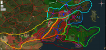
On the map, regions are shown by bright outlines; rivercourses, both existent and suggested, are in blue; (not all) roads and towns (and town-like settlements) are in pink and purple; red rising diagonals are for mountains, green rising diagonals for forested uplands and green falling diagonals for forests of Kingswood and Rainwood (the map doesn't show all the forests, as they should be determined at local scale). All the things are just approximations.
Despite being relatively small region, Stormlands nevertheless are quite geographically diversed, mainly due to abundance of various natural features, like mountains, that divide it. Generally speaking, Stormlands aren't the most economically powerful realm, nevertheless, they are strongly self-sustainable, as they existed as indepentent kingdom for centuries. Now, to the descriptions of each region, using scheme: general information/natural features/agriculture/trade and industry.

Region A - Northern Stormlands. As I suggested before, this region historically served as the socio-economic powerbase of Durrandons/Baratheons and their immediate vassals, altogether constituing the force that kept Stormlands united. This region is effectively divided into two by central forested uplands (passage through which is guarded by Bronzegate), with smaller southern part heavily affected by storms and heavy rains from Shipbreaker bay, from which bigger northern part is lagrely protected by said uplands.
Southern part, region A1. This region truly can be called the core of the core, THE storm's land, that gave the name to the whole Stormlands. Because of geographical location, landscape and climate, this part in my opinion is mostly similar to Atlantic coasts of Scotland and Ireland, with heavy rainfall and frequent storms.
As such, agriculture and economy are somewhat similar too. The main grain crops grown here are oat and barley, especially oat, as both are quite lenient crops, especially fitting for wet and not very fertile soils. Other crops, like wheat and rye, are grown in smaller scale, as both need drier conditions. Animal husbandry is quite prospering here, first of all, of cattle and sheep, because of abundance of moist grasslands for grazing, especially close to coast, where regular storms prevent growth of dense forests and hinder field farming. Pigs are also kept in more inland settlements. Also, few fishing settlements exist on the dangerous coast, catching not only fish, but occasionally sea amber from Rainwood as well, thrown onto coast by tides and storms.
This subregion has only two settlements that can be called towns, both only suggested by me in previous posts: Durrangard and Connington, serving as centres of trade and crafts. Despite being not very fertile land for agriculture, this subregion is nevertheless quite populated, because of two geostrategical aspects: 1. general safety from incursions from Reach and Dorne, because of remoteness and natural barriers of mountains and uplands, as well from sea, because of generally unpleasant shores: 2. medial position in Stormlands, controlling inland trade routes. Also, lands are secured and favoured politically, as being the domain of the Stormlands' rulers. Durrangard is the biggest city in all Northern Stormlands, serving as general centre of commerce and various crafts, with any particularly prospering industries open to be determined. Two industries in this subregion are logically derived from agriculture here: leatherwroking and wool-spinning for making cloth. But wool also can be exported to craftsmen, spinners, in KL, like it was done in Middle Ages from England to Flanders.
Northern part, region A2. This is far more calm lands, effectively part of Central Westeros plain, through being somewhat an isolated offshot of it.
Most of it belongs to the basin of Wendwater. As part of unfinished Felwood, some interesting upper parts were made, through unfinished. On the map you can see my rough suggestions for realistically enlargened basin of Wendwater, the river with its confluents, courses painted on current Wendwater, unfinished upper parts in Felwood lands, as well as my suggestions. Starting as smaller streams, Wendwater and its confluents are originating in broader area from forested uplands on the border with the Reach, from northernmost slopes of Red mountains and from central uplands of Northern Stormlands, gradually absorbing brooks here and there and merging into a bigger river. Wendwater with confluents serves as one of principal ways of transportation in these lands.
This subregion, being mostly a hilly plain, with adequate precipation and temperature, is the main grain producing place in Northern Stormlands, and, perhaps, in whole Stormlands, in combined output. Full variety of grain crops is grown here, mostly wheat and rye. Names of Haystack and Felwood suggest that these lands are quite cleared and cultivated. With abundance of fodder, animal husbandry is also prospering here, mostly of cattle and swine. The name of the Parchments suggests that leatherworking is a prospering craft here. Part of old forest, Crownlands' part of which became Kingswood, still covers the northern part of Stormlands with other forests located here and there, just like nearly everywhere else in Stormlands, especially on the uplands and foothills of mountains, offers great hunting grounds, as the name of Fawnton implies as well.
Beside quite a lot of hamlets and villages, few town-like settlements are located in this subregion as well. The main factor for growth of them was generally peacefull time of Targaryens reign, that fostered trade between previously rival realms, while creating new trade routes as well. As such, suggested by me in previous posts, Robertsbridge, the town located by the bridge on Kingsroad and having a river-port on Wendwater, appeared and grew just as the King's Landing and Kingsroad apperead and grew themselfs, while I suggest that Fawnton, located on old road to the Reach, grew due to intensified trade with this realm (the recent (during last 300 years) growth of prosperity of towns and lands of various vassal lords of Baratheons aligns well with the fact that many of them revolted against Robert in the Rebellion, as their powerbases grew enough for showing such disobedience). Agricultual goods, first of all, surplus of wheat and rye, are exported both to southern part of Northern Stormlands, as well as to King's Landing by Wendwater. Also, some metals and minerals, mined and smelted on the northern side of Red mountains, are exported by Wendwater to craftsmen in KL, as well as some other goods possible.
Speaking of Northern Stormlands region in general (A1 and A2), beside grains and common vegetables, some other crops are grown. Fruits here are generally Middle European, such as apples, pears, plums and berries. That means, that some cideries can exist too, especially in A2. Also, in both subregions conditions are fitting for large-scale growing of hop, so beer breweries can be quite widespread, with beer serving as characteristic replacement for wine in Stormlands.
Also, both subregions are fitting for large-scale growth of hemp, especially A2, so the neat new blocks can be utilisied too and production of hemp textiles, ropes and nets can be important industry here.
Also, there must be 2-3 quarries in Northern Stormlands, both for production of stone and lime as well (I suppose, geologically Northern Stormlands are composed mainly of sedimentary stones, like limestone. That also aligns with description of cliffs near Storm's End). Also, because of abundance of forests here and there, especially in uplands, there should be quite some logging camps with sawmills in settlements.

Other regions are on the way, I'm continuing right now...
 

Attachments

  • Rough geo-economical map.png
    Rough geo-economical map.png
    1.4 MB · Views: 65
Last edited:

Nikas Kunitz

Herald
Part 2. The plains of Dornish Marches (region B).
The famous region that always was a buffer zone, constantly ravaged by wars and conquests, the Dornish Marches (of Stormlands) are divided by Red mountains into two parts: coastal in southeast, broadly including Slayne valley and Red Watch, and inland northern part, consisting of windswept plains (that stretch further into the Reach part of the Marches). Geography of the inland part of Marches is determined by Red mountains, stretched in several prolonged rows with dales inbetween. Mountains largely prevent passage of wet airmasses from the Dornish sea, while Sunset sea and Narrow sea are away from this region, making dales and lands directly north of the mountain ranges a dry windswept, woodless grasslands. Forests do exist, but only in some uplands and montane areas, mainly consisting of pines and other trees that aren't very water-dependent. No rivers exist here, only some brooks and streams, that flow into lakes in the dales, with only one stream going to the sea, in Gallowsgrey and Blackhaven lands.
As region was constant area of wars, settlements always remained scarce, both because of raids and fear of raids. Even through some degree of peace was achieved when Dorne became part of the Seven Kingoms (after quite bloody wars), population remains scarce, through number of settlements slightly increased in last century. Also a relative lack of water disfavours agriculture in these lands. Cultivated lands exist only nearby settlements, near some adequate water supply. Main grain crops grown here are wheat, and, especially, rye, as rye is both quite dry- and coldresistant. Agricultural production satisfies only local needs, local settlements and castles. However, grasslands offer possibilities for animal husbandry of cattle and, especially, sheeps and goats, by open herding. But, in my opinion, the most notorious and profitable sphere of agriculture in this region is horsebreeding. Open grasslands for grazing and military needs logically fostered horsemanship and horsebreeding traditions for centuries. Of course, horses are breed in other agricultural areas of Stormlands too, but a lot of both finest and cheapest horses are exported from the Marches, likely making one of the few trades that give profit to Marcher lords. Beside wheat, rye and livestock, only common vegetables are grown if possible, there're no fruits or any other crops, because water is limited and temperatures are quite extreme.
Having no strong agricultural basis, there are no much big settlements in this region. Few craftsmen are satisfying only local needs. The most developed and prospering settlements of the Marches are located on the important roads, that connect the Reach and Stormlands with Dorne with passes through Red mountains. Passing trade roads foster the developement of settlements as points of rest and service for merchants and wayfarers, while also having markets, where goods are bought and redistributed among other settlements in the Marches. Only few local crafts can offer goods for export, like, I suppose, bow-making (that aligns with mentioned reknowed proficiency in archery of Marchers. I propose that Dornish Marches (in general, not only this part) are one of the few places in Westeros (all others are likely in Dorne) where making of composite bows is known and traditionally practiced, so local masters are unique, that also aligns with other crafts I propose right further), and bone and horn crafts, because of materials common here, as well leatherworking, through very limited, because it requires quite a lot of water and other things. Few mines also can exist in foothills of Red mountains, but scarcity of food production heavily limits the possible number of mining or other workers. Also, even through forest in uplands and montane areas offer quite good timber, there is no large-scale logging, as there is no effective transportation for timber (this requires suitable rivers, as timber cannot be effectively, regularly transported in large scales by land).
So, inland Marches are somewhat a backward region, but quite unique for Westeros, a bit resembling steppes of Essos. If Westeros is Europe, Dornish Marches are roughly, very roughly alike Hungary or, geographically, Hungarian plain as an island of steppe in middle of Europe, through real Hungary is quite favourable place without such continental climate.
 

Nikas Kunitz

Herald
Part 3. Southern Coast (region C)
Stretching from Dornish Marches, through shores of Slayne's mouth and Red Watch to Weeping town, this region is prosperous and populated not less than Northern Stormlands. Favourable calm warm waters of Dornish sea give this land stable warm sea climate with plenty, but not excess, of rain, while the soils (in western part) are enriched by volcanic acitivity of Red mountains in the past. The main disadvantage of this land historically was its proximity to Dorne, with frequent Dornish raids pillaging local settlements and burning fields. This region is half-isolated from the Northern Stormlands by Red mountains, forests of Rainwood and waters of Shipbreaker bay, so quite distinct economical region had developed here, historically dedicated mostly to self-sustaining against Dornish attacks. The peace, that was achieved with Dorne in last 100 years, fostered trade with this realm and growth of prosperity of this region. This region effectively overlaps with regions D (Slayne valley) and E (Cape Wrath), so they are largely intervined, through I designated regions in such way because this Southern Coast region forms distinct ciltural landscape, with clearly more settlements and cultivated land than regions of Slayne Valley and, especially, Cape Wrath.
Agricultural productivity of this region can rival and outrival that of Northern Stormlands and even can be compared to some areas of the Reach, through this region is much smaller and isolated. A full variety of grain crops is successfully grown here, with wheat predominating. Animal husbandry is well-developed, through it doesn't have such important role as in many other regions of Stormlands, as cultivated land is mostly dedicated to productive farming here. Nevertheless, swine and cattle fully satisfy local need in meat. Alongside common vegetables, some southern crops and herbs are growns here as well, through in much smaller scale than in Dorne or in Southern Reach. Alongside thriving apples, pears, plumms and berries, some fruits, like peaches or apricots, are also grown here (but no citri nor pomegranates), through in small, local scale, not reaching tables even in Northern Stormlands. Perhaps, grapes are grown here as well, but local wines aren't very good, making large-scale viticulture unprofitable, especially in competition with such producers as Dorne and Reach, so few small wineries satisfy mostly local nobles and merchants. Beside, there is no much of land that could be dedicated to it. Also, fishing is prospering here, as waters are quite calm, so most of coastal settlements have some fishing facilities.
Strong, self-sustainable agricultural base enabled large settlements to grow here. One is Weeping Town, the biggest settlement in Stormlands, serving as its sea gate to Dorne and Essos (I will specifically talk about WT in post about Cape Wrath, as economically it leans to this region. I included it in Coastal region, because it nevertheless belongs to this cultural landscape). I suggest that there also should be quite big town at Stonehelm, on eastern bank of Slayne (for safety from Dornish raids by land), serving as economical hub of Slayne valley and Red Watch (moreover, Swanns of Stonehelm are mentioned as likely second only to Baratheons in power among Stormlands' lordly houses. I have even more radical suggestion of making town at Stonehelm not lesser than Weeping Town, while making these two and Durrangard somewhat of comparable size, as the only three "true" towns of Stormlands). This Stonehelm town is focal point of all Southern Stormlands economy, where both agricultural products and natural resources, like metals and timber, from Red Watch and Slayne valley, are concentrating, using Slayne as major transporting route. So, this town has broad variety of crafts, needed for self-sufficiency of the region, while I suppose that steel weapon- and armour-making are, perhaps, the finest in all Stormlands, due to abundance and quality of needed resources and strong martial needs and traditions. Beside crafts, this Stonehelm town is also important trading place, with busy port and market, where some goods are exported, while many are imported, with Northern coast of Dorne as main trading partner.
 

Nikas Kunitz

Herald
Part 4. Slayne Valley (region D)
Geography of this region is determined by Red mountains and its continuating uplands. Effectively surrounded by all sides, but one in south and south-east, it is largely isolated region with river Slayne (and roads going along its banks) serving as major connecting route with outside (few small mountain paths can exist, but they aren't effecitve route). Mountains also influence climate of this region - it is much cooler and continental than of previously described coastal region. The landscape is constituted by montane valleys of Slayne and its confluents. Even through not as much populated as regions C or A, this region still has considerable population, concentrated in lowlands along rivers, especially along Slayne, as it forms biggest valley, but on some suitable plateaux as well. While uplands and mountains are far less populated and are covered by dense forests and alpine grasslands (and tundras on higher latitudes). Generally, Slayne, by its location and environment gives me an impression of Rhône, especially of its more highland Alpine parts, surrounded by mountain ranges. Also, I suggest prolongating river course of Slayne, making it start as stream far in the highlands (maybe even from some glacier, if enough space for such landscape can be found), with its famous rapids and waterfalls being characteristic of its upper half, while lower half is more stable, yet fast, river, broad enough to be used as effective transport route (Parallel with Rhône is also evident here, as it, being not as long as Loire and quite the same as Seine, is more than double of them in water volume)
Agriculture is determined by montane environment, with its pros and cons. Farming is largely concentrated along the river Slayne and its confluents, especially grain field farming, with main grain crops being wheat and rye, while smaller plots, mostly used for common vegetables, can be found on higher plateaux. Scarcity of usable land generally limits farming to meeting local needs, without much export or trade. On the other hand, animal husbandry is prospering here, with a lot of grasslands on mountain slopes and river banks providing much of grazing grounds, mainly for cattle. While dairy products, first of all, cheese, are made everywhere where cattle is common, like in Northern Stormlands, nowhere in Stormlands cheesemaking is so important and prospering as in this region. Cheesemaking is important local industry and tradition with production of considerable quality and quantity. It satisfies local needs with considerable export downways river Slayne to the Coastal region, where it is consumed and exported beyond, by land or sea, to other regions of Stormlands and to Northern Dorne. Perhaps, in times of exceptional abundance, Slaynese cheese reaches even King's Landing. Anyway, I suggest that cheese is main and most profitable agricultural export of this region.
The main wealth of this region is constituted by its natural resources, through production (logging and mining) of them is hindered by small agricultural base. There is considerable timber logging, which utilises river Slayne as main transport route for logs downways to Stonehelm. Red Mountains are quite abundant with mineral riches, through exact minerals and locations are largely open to be determined. What, in my opinion, definitely should be present is rich iron ores (perhaps, if we take name of Red mountains literally, the red colour can be caused by abundance of iron oxides). Also, copper and silver (also lead, as it is often produced from the same ore as silver) can be present in smaller quantities, as well as some gems and semiprecious stones. Even through some maps state that amber is mined in Stormlands, I think that primal source of amber should be forests of Rainwood, amber from which is dispersed in Shipbreaker bay and thus collected as sea amber, as it was in real Baltic sea - primal source of amber in Europe. A lot of settlements in this region are connected with mining activities and immediate prime processing (crushing ore and smelting metal as pieces), with most of processed resources are transported by Slayne downstream to craftsmen in Coastal region, mainly in suggested Stonehelm town.
Also, both in this region and in the Coastal region mentioned above, some quarries should be present, as sources of stone, commonly used here.
 

Nikas Kunitz

Herald
Part 5. Cape Wrath (region E)
One of the most famous and peculiar regions of Stormlands, Cape Wrath has unique geography that determine its specific economy. Being mostly covered in Rainwood (with notable exception of southern coast, which thus makes it a different cultural landscape of cultivation and population, nevertheless economically connected with the rest of Cape Wrath), landscape of this region is determined by this natural feature, this forest. As I suggested in my previous posts, in order to fit the fact that this land wasn't largely cleared and populated (as this land has quite favourable strategic position, with proximity to Essos etc), I suggest that Cape Wrath, particularly the parts covered by Rainwood, should have quite uneven terrain, with a lot of high hills, cliffs and dales, hindering possibilities for clearing and cultivation. A very heavy rains and occasional storms (mainly on northern coast and on the tip of Cape Wrath) give Cape Wrath a lot, an excess of precipation, which turns into a lot of streams and rivlets, many of which go into inland lakes and wetlands, while others, quickly forming short, but relatively broad rivers, go into the seas around Cape Wrath. While lowlands of landscape of Rainwood are covered in lakes and wetlands, with streams and rivers going off the hills, slopes and watersheds of those hills are densely covered in lush forest. Such landscape offers very limited possibilities for cultivation, so only coastlines and some favourable inland places (like broad hills/plateaux) are somewhat populated.
In such uncomfortable environment, agriculture is very complicated, serving only needs of local small populace scattered in hamlets lost in the Rainwood like small islands in a sea. Main grain crops here are oat and barley, with oat overhelmingly predominating (as I wrote above, oat grows exceptionally well in overly wet soils, unlike wheat, while barley is generally less fastidious. Rye is too, but still requires better drained soils, Only oat grows well in apparent wetlands and moorlands). On better drained landplots (thus, as up hill from lowlands as possible) common vegetables are grown, most of which are root vegetables especially prone to rot from over-moisture. Animal husbandry is hard too, only few cattle and swine are kept in small scales. As nearly all of the land is covered in forest, there are no big open grasslands that could be used as grazing ground for cattle, through some such grasslands exist here and there on northern coast, where regular storms keep dense forest distanced from the shore (broad southern plain is part of region C). Nevertheless, struggling agriculture is compensated by hunting and foraging, which play as important role, as nowhere else in Stormlands. Rainwood offers plenty of game to hunt, as well as plenty of mushrooms and wildberries to gather. As usable land is extremely scarce, it is fully dedicated to vital food agriculture, so neither luxurious fruits or grapes are grown here, nor industrial crops, like hemp. Only flax is sporadically grown here in small scale for local uses, as it grows well in wet soils.
The main and nearly only export (not entirely true, read further) of Cape Wrath is its prime timber of various kinds from Rainwood, with the forest seemly being an infinite source of it. However, as I mentioned in previous posts, cutting isn't the main issue of timber trading, the main issue is the transportation of logs. Even with the best roads, effective transportation of logs by land means is (was until XIXth cent.) impossible on regular basis (land transportation can be used to transport logs on local, temporal scale, for example, at instance of building something), because horses or mules themselfs cannot transport large amount (tonnage) of logs in carriages, while such burden on regular schedule will likely quite quickly exhaust hauling animals to death (In real world, regular transportation of large amounts of logs by land became possible only with steam-powered trains and successive moving machines). Instead of killing mules, timber was transported, on regular basis and large amounts, by rivers downstreams, simply as singular logs, or as rope-binded rafts, or (later) by barges, in all ways, set free to flow with current. Inland part of Cape Wrath, i.e. Rainwood, obviously (especially with landscape I suggested) has no roads other than irregular narrow paths between hamlets. Only exception of that is the strategic road running between Northern and Southern Stormlands, but it lies on the very edge of Rainwood in eastern foothills of Red mountains, where forest isn't so dense, so the road was cutted here (lands of Crowsnest are located on this road, as well of Broadarch if current location will be kept). So, I suggest that these short, but voluminous and broad rivers that are formed by countless streams (the ones that don't end up in isolated inland lakes) in Rainwood and are going to sea, should be the main transportational way into the depths of Rainwood, with nearly all settlements (and all big settlements) being located along these rivers. Timber logging, as the main trade in Cape Wrath, is organised around these rivers, with logging camps and settlements scattered along them, using these rivers as transportational route for logs. On lower parts of these rivers, sawmills and timber markets are located. As this is the most profitable trade here, I suggest that most of castles and biggest settlements are located near mouths of these rivers, where coastal plains also provide them with food (for example, Herston, Toyne and Gower, also Amberly and Rainhouse. And, of course, Weeping Town), while some castles and lands are located inland (Mistwood and Bolling, maybe some other), on longest of these rivers, that connect them with outer world. Beside wood, Rainwood forest also provides a lot of amber, that is an important exporting good as well.
In my opinion, main importers of Cape Wrath timber are islands of Tarth and Estermont, ports on Narrow sea coast of Westeros and Free Cities and also Dorne in last century. Main reason for import is to maintain big fleets, as Free Cities, Dorne and islands have no such quantity and quality of timber as Cape Wrath can offer. All the coastal settlements of Cape Wrath try to sell timber, but the main and most prosperous one is Weeping Town, for number of reasons. First, I suggest that WT is located in mouth of longest of Rainwood rivers, making it a hub for big area inside of Rainwood. A greatest number of logging camps are located along this river. Additionally, I suggest that Mistwood should be located on upper part of this river, as such connected through WT with outside world. The second reason for prosperity of WT is that it occupies the biggest and most comfortable haven, the easternmost such in Cape Wrath, making it strategic port, closest to Essos. In the past times, when Stormlands were independent Kingdom of Storm, WT was the main shipyard of the realm, due to abundance of good timber, good haven and its strategic location in Narrow sea. Most of ships of Stormlands Royal fleet were built here, and later based in ports of Tarth, Estermont, Sweetport and Southern Coast, as well in WT itself. But after Stormlands became part of Seven Kingdoms, importance of having its own fleet largely decreased, especially in last century before the Rebellion, as Dorne ceased to pose a threat. In new realities, role of WT shifted from main shipyard of the Stormlands to important point in maritime trade on Narrow sea. Not being an important end destination for merchant ships, as WT is quite remote from main populated areas of Stormlands (through trade, of course, is going), this town is an important stop and resting transitional point for ships sailing on Narrow sea between other, end-destinational, ports, especially before and after passing dangerous waters around the tip of Cape Wrath, Shipbreaker bay and generally stormy central Narrow sea (see my post about storms above). So, shipyards. earlier used to build ships for Stormlands fleet, currently are used mainly for repairing and maintaing ships from other places, stopping in WT in their voyages. Some ships are still built here too, particularly, I suppose, WT is one of main shipyards building ships for Royal Fleet. So, exporting timber, importing some goods, repairing passing ships and occasionally building new ones constitute wealth and raison d'être of Weeping Town.
In additional to timber itself, wood industry also provides such important (especially for ship building) products as tar and pitch, that can be even more profitable than selling timber. I suggest, there must be a lot of tar-making facilities and storages around Weeping Town and other wood-working villages.
Also, abundance of wood likely causes woorworking traditions to exist, so various woodcarvers and woodcrafters can be widespread in this region too, making unique and reknown wooden crafts, that can also constitute a considerable export.
 

Nikas Kunitz

Herald
Additions, or important things I forgot at first.
Flax
(and cloths). I suggest that flax is common in Northern Stormlands (region A), just as hemp is, but hemp is more predominant in drier subregion A2, while flax is in wetter subregion A1. With considerable growing of flax and hemp, and large-scale herding of sheep in subregion A1, I suggest that, beside general variety of crafts needed for self-sustainablity of the region, main industry in supposed Durrangard should be spinning and clothmaking, of linen, hempen and woolen textiles/cloth. This town should be main textile-producer in Stormlands, more-or-less supplying the whole realm. Through this industry experience hard pressure and competition from much more colossal industry of KL (producing cheaper cloth), Baratheons (more like, guilds from their Durrangard, which provides Baratheons' greatest revenue) try to keep industry at Durrangard sustainable. I suppose, issue of tolls on cloth remains highly debatable matter between Storm's End, Iron Throne and some hemp and flax producers in subregion A2, who try to sell raw flax and hemp to either KL or Durrangard, for greater price either side can offer. As, I think, a lot of such economical issues are common between competing producers all over Westeros.

Furs. As a lot of Stormlands are covered in forests, I suppose that hunting for precious furs is one of widespread economic activities in forested areas, especially in Cape Wrath. Selling of various furs to other areas of Westeros, where forests are lesser and fur animals are rarer, can give much profit to lords and merchants of Stormlands. Especially to direct neighbours: KL, where much of city population of middle and high classes try to look as richer as possible, and to Dorne, where fur animals are logically as absent as suitable forests are. Also, from Cape Wrath, particularly Weeping Town, furs can be exported to Free Cities.

Few correcting notes on Inland Marches (region B). The description that I proposed is applied to most of its landscape. Of course, places where Marcher lords raised their castles are the ones with the best conditions in the region, that's the area between castles with their villages which is mostly wild grasslands, with little isolated settlements. Fiefs, that are especially close to border of the Reach, like Harvest Hall and Poddingfield, have best lands, as they are located on much better transistional zone to adequately moisted lands to the north, so they are especially strong economically, producing a lot of grain, mostly wheat.

Rivers in Cape Wrath. The small and broad rivers I supposed for this region, aren't really broad to be fully navigable. They are used by boats and for flowing logs, any large vessels can't go through them. They are broad in reliance to their short lenght, not in absolute measure. Because there are several (in "real" scale of Westeros, many) such rivers, and they aren't really particular in themselfs, and they don't connect any broad and diverse territories, they aren't seen as "true" rivers, so Cape Wrath has no major rivers to be reknowned.
 
Last edited:

Nikas Kunitz

Herald
Additional "economical" activity in coastal regions, for fishing villages on the shores of Shipbreaker bay (regions A1 and northern Cape Wrath). As quite some ships try to pass the bay despite dangers it has, even in bad season, some of them can be catched by a surprise storm and crashed on coastal rocks and cliffs or end up crashed on shore. This may leave a floating or landed shipwreck and, as it often was, scavenging it was quite common for locals. So I propose having sorts of scavenged shipwrecks or scavenged cargo in fishing villages, as a good way to show the nature of Shipbreaker bay in addition to having some shipwrecks and ship parts on rocks and cliffs in the bay. Even through patents and insurances on ships and cargo goods existed in Middle Ages, protecting ships and goods as private property, the traditional custom was common as a law - shipwrecks and cargo belonged to the one who found it, or to the local lord, or shared between them in some proportion.
 
  • Like
Reactions: DjTorec