Sunspear/Dorne Redo Discussion Megathread

jmcmarq

Envoy
View attachment 10791View attachment 10790

Hope this rough drawing helps to visualize how I see the possible dornish inspirations.
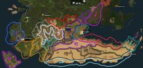
Replying the amazing map, done by Azulejo, I would like to suggest more concrete inspo, based in what was shown, i did this map

region inspo.jpg

Region 1: Cordillera Cantábrica and northern green Spain regions, (Asturias, Cantabria, Euskadi, Picos de Europa...)
Region 2: Galicia, Macizo Galaico, the images of the romanesque areas of the Camino de Santiago
Region 3: Provence and the Mediterranean France, Roquefort could be very great for this area
Region 4: The French Hautes Pyrennees, Bigorre, Neouvielle, Gavarnie, Le Tourmalet...
Region 5: The Spanish Pyrennes (Central Pyrenees such as the areas of Ordesa, y Monte Perdido, Tena, Biescas,)
Region 6: Aragón, Navarra and Castilla León, with the inland valleys of the central Northern Spain , (El Teleno, Moncayo, Las Médulas, Riglos...)
Region 7: Croatia, I tnink the works done by WRMD fit perfectly for this area.
Region 8: Catalonia: Mountain Northen Areas: Vall D'Aran, Nuria... South ranges and shores: Montserrat, Montseny, Costa Brava...
Region 9: Portuguese Alentejo and Algarve
Region 10: Croatia and Greece, Good Job done by Eld
Region 11: Sistema Central of Iberia, Sierras de Guadarrama and Gredos, Valles de Navacerrada, Segovia, la Pedriza, la Vera y el Jerte.
Region 12: Serra Tramontana in Mallorca and the rocky shores of Valencia, Castelló and Alicante.
Region 13: Shoreline mountains nearby Almería, or Cartagena. The shores of the Palos/Gata/Tarifa capes can fit very Great there.
Region 14: Andalusian and Murcia Shorelines (Costa Cálida/del Sol) and ranges: (Sierra Morena, Serranía de Ronda...) Good Job done there by Marg.
Region 15: The hot Iberian Mesa, Castilla la Mancha, Community of Madrid, and Extremadura, I would do there a large mesa slightly green
Regions 16-17: The Sistemas Béticos and Sierra Nevada.
Region 18: The desert areas, valleys and oueds of the North Africa (Morocco, Algiers, Lybia...
Region 19: The Atlas Range
Region 20: Shorelines of Esaouira and Western Sahara.
Region 21: La Côte D'Azur and Monaco

Thanks
JMC
 
Last edited:

Azulejo

Bloodmage
Staff member
I love all of this Azu. I think our best option would be a Greenblood megabuild including Vaith, Godsgrace, Lemonwood, and the extinct houses of Dorne. It would be the only way we could get good consistent terra along the river.​
I fully agree.

Azu you are a beast ma man​
Thank you! It helps that my degree project (idk if it's said like that in english?) is somewhat related to this :p.

First of all, I want to talk about natural environment. I totally support making canon-accord stony desert of Eastern Dorne in contrast to sandy desert of Central Dorne. Being in line with suggestions above I think that this desert shouldn't be just a barren land, but should have some vegetation as well.​
Yes, I agree. Mainly because East Dorne is not a desert, so some vegetation would exists. I made a post in this same thread with inspiration for the area with several degrees of dryness and amounts of vegetation. It would probably change in different regions of East Dorne.

As such I propose making uplands, first of all, eastern slopes, where Scourge and Vaith are originating, generally greener, as due to elevation, even scarce wet air is catched here even during dry seasons, and that feeds Scourge and Vaith all the time, through the two (and Greenblood as well) are quite small rivers during dry season, in contrast to being real rivers during wet season.​
I agree on the need to make the mountains where the Vaith and the Scourge more green (don't go crazy though), as they would most likely catch the water that feeds the dornish river system. One thing tho, even in dry periods of time the Greenblood has enough water to substain Dorne. They're small but not insignificant. I also agree on the existance of many seasonal rivers (we call them ramblas or barrancos) in East Dorne, especially coming from the mountains at Ghosthill and Tor.

I think that Stepstones, Broken Arm and strip of coast from Greenblood mouth to Spottswood (so, including Sunspear) should be not deserts, but generally mediterranean coastline, quite green even during dry season, covered a lot by farms and orchards, supporting towns of Plankywood and Shadowtown with fruits and livestock, while grain comes mostly from irrigated Greenblood valley.​
Well not only those areas, but all of East Dorne is not a desert. They're drylands, not desert. There's an important difference. Canon somewhat supports what you are proposing here. Lemonwood and Spottswood are names that suggest the existance of some forested area, at least in the past. And the High King of the Greenblood, prior to the arrival of the Andals, had their sit on a wooden moat-and-bailey fort in what now is Lemonwood. One could argue climate has changed since then, if we consider the break of the Arm of Dorne as water raising, but I'm not sure about that. However, while mediterranean, this are is not The Arbor, it's drier and for sure less lush.

I don't agree on the distribution that you've made of agriculture though. Orchards are by far the crops that require the biggest amount of water, so they would be concentrated along the Greenblood, while rainfed crops like grains can grow on the east coast of Dorne. The Greeblood would produce both fruits, vegetables and grains, while the farmable area along the coast would be more clearly dominated by grains, wine and olives (we call this crops triología mediterránea), and orchards would appear only in irrigated areas as they do in the Greenblood. Marge has done a really good example on how this crops are distributed in The Tor. Look how olives, vines, most spices and wheat are in the non irrigated areas, while fruit orchards, vegetables, cotton, rice... are on the areas with easier access to water (torhamlet3 being the biggest example). Here some more info on dryland farming, what would probably take place in East Dorne, specially on the coast.

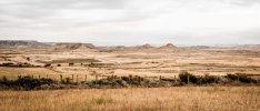
drylands xpath unsplash Bernard Hermant.jpg
This is what I imagine most of East Dorne, specially inland, would look like.

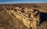
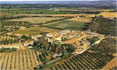
imagen_Soria_Rello.jpgCute walled village in East Dorne (it just needs a light arab spin and done).

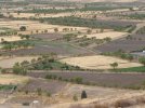
Camposcala.JPG
Dryland crops in Granada.

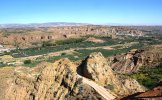
Guadix 2.jpgBaza 2.jpg
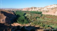
Seasonal streams in East Dorne would probably look like this, when populated. Green strips along the drylands. Water would be either pumped from the waterbed, with qanats or by the many other means available.

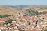
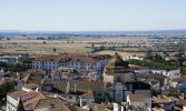
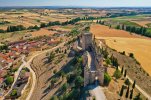
Sigüenza.jpg1200px-Evora_view.jpgE3CQyRUWYAMCc9r.jpgunnamed.jpg
This images are what I think the wetter areas around Lemonwood, Spottswood and Sunspear would look. More wet/lush than this, specially without aditional sources of water, would be excesive.

Greenblood waterworks.jpg
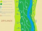
Very (very) rough scheme on how crops would be distributed in the Greenblood.

I've talked about this before on this same thread but basically there would be one or two main canals parallel to the Greenblood formed by a weir or azud upstream, From this canals smaller ditches with water would irrigate the crops. Those ditches going downwards from either the river or the canal would irrigate orchards and vegetables, the crops that need the most water, since is easier to transport big amounts of water with them. Water ditches going upwards from the river or the canals would fed crops with smaller needs of water, like wheat, olives, vines (some kinds) and date palms (plantations, indiviudal date palms would be dotted all around the Greenblood), since this crops need less water and the amount yielded by hand, water weels, animal weels (saqiyah)... would be enough. Also concentrating dry tree crops like date palms or olives at the edge protects the fields from drier air from the drylands or ocasional (ocasional, remember THIS IS NOT A DESERT) dust storms.

As our timeline is somewhere in early autumn, I think general Eastern Dorne landscape shoul be dominated by dry lands, rowed by dry watercourses of streams from uplands feeding Greenblood during wet season, with dry-sustainable vegetation here and where, while the coastal area from Lemonwood to Spottswood, alongside with Broken Arm and Stepstones, should have pretty Mediterranean landscape, like the Tor coast.​
Yes.

Now, to more cultural and historical aspects. As it is evident in canon, prior to Rhoynar arrival, Dorne was dominated mainly by lords based in "greener", less season-affected lands, like Yronwood and the Tor, while Jordaynes of Godsgrace sustained on all the yield that Greenblood basin could give by "primitive" farming. Martells, based on eastern coast of Dorne, quite green (as I suggested above) were self-sustained as minor lords, but couldn't be anything more with such small economical powerbase. The arrival of Rhoynars brought not only centralised force, by alliance with which Martells became the major house, but important technologies as well. Just like Romans and Arabs brought their aqueducts and norias to Spain, Rhoynars brought advanced irrigation and water-management techniques from their homeland basin of Rhoyne. These technologies, alongside with general population influx, enabled to turn Greenblood into a much more productive agricultural area, with rational irrigation, utilising river's overflow during wet seasons, as well as making farms and orchards in coastal strip around Sunspear (and in Eastern Dorne in general) much more productive. This turned previously backward Eastern Dornish lands into a far more prosperous lands. Increased agricultural yields and proximity to Essos for trade, sparkled the growth of large settlements and towns in Eastern Dornish coast. All of these served as effective socio-economical powerbase of Martells and their immediate vassals, so the house of Nymeros Martell was able to keep its dominant position in Dorne for all the centuries,​
Yeah, I think we can all agree that's what most likely happened. The usage and careful management of the river overflow during wet seasons is somehting that happens more at the Nile, an area I would try as much as possible not too overuse when making the Greenblood. I don't personally think the Greenblood floods periodically like the Nile does. Such big event would at least be mentioned. Yes, of course the water yield gets bigger during wet seasons, but it does not flood the croplands, at least not peacefully and predictably. Floods, whenever they happen, would be probalby very catastrophic.

As such, cultural landscape should consist of following: as Azulejo suggested, the lower Greenblood valley is dominated by irrigational works, channels and reservoirs, mainly for produce of grain in my opinion (wheat and barley, but maybe even rice as well), with multiple villages along the river and Planky Town in its mouth; eastern Dorne coast should be dotted by villages with orchards and farms (with livestock!) with Sunspear agglomeration as main settlement, while inner, drier regions of Eastern Dorne should have small villages here and where, with inhabitants waiting wet season for starting agricultural works and mainly grazing small cattle until then.
I've already explained how I differ on the crop distribution you mentioned. Regarding the settlement pattern yeah, I agree for the most part. I've mentioned alquerías before as an interentings type of settlement for the area. Canon sais Planky Town is the biggest settlement in Dorne, while the Shadow City/Sunspear is the closest thing to a true city dornishmen have, probably due to the peculiar nature of Planky Town. Inner East Dorne would have small villages, as you said. We have to keep in mind that Dorne is the least populous of the 7 kingdoms (but remember, the Stomrlands include the Crownlands and the Iron Islands are part of the Riverlands in this subdivision), so most population would be concentrated along the Greenblood, the coast and the moutain valleys. Livestock would probably graze in the drylands, I agree on that.

P.S. Why Martin hadn't named Greenblood as [new] Little Rhoyne, this name could fit it so much.
Cute name! Well Rhoynar were a minority that integrated in the dornish society. Unlike in the Iberian Peninsula, where arabs became the ruling class and with time their language became the norm (thus changing the place names), Rhoynar became part of the dornish society as equals, so it wouldn't make much sence for the main river of Dorne to change names. Nymeria and her people made a big effort in blending into their hosts.

I'm been fussy with all of this Nikas, what you've said and proposed is quite good, and for not being an expert on dry and mediterranean areas it's really well done! i'm just using your post to bring up more points :p
 
Last edited:

Azulejo

Bloodmage
Staff member
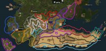
Replying the amazing map, done by Azulejo, I would like to suggest more concrete inspo, based in what was shown, i did this map

region inspo.jpg

Region 1: Cordillera Cantábrica and northern green Spain regions, (Asturias, Cantabria, Euskadi, Picos de Europa...)
Region 2: Galicia, Macizo Galaico, the images of the romanesque areas of the Camino de Santiago
Region 3: Provence and the Mediterranean France, Roquefort could be very great for this area
Region 4: The French Hautes Pyrennees, Bigorre, Neouvielle, Gavarnie, Le Tourmalet...
Region 5: The Spanish Pyrennes (Central Pyrenees such as the areas of Ordesa, y Monte Perdido, Tena, Biescas,)
Region 6: Aragón, Navarra and Castilla León, with the inland valleys of the central Northern Spain , (El Teleno, Moncayo, Las Médulas, Riglos...)
Region 7: Croatia, I tnink the works done by WRMD fit perfectly for this area.
Region 8: Catalonia: Mountain Northen Areas: Vall D'Aran, Nuria... South ranges and shores: Montserrat, Montseny, Costa Brava...
Region 9: Portuguese Alentejo and Algarve
Region 10: Croatia and Greece, Good Job done by Eld
Region 11: Sistema Central of Iberia, Sierras de Guadarrama and Gredos, Valles de Navacerrada, Segovia, la Pedriza, la Vera y el Jerte.
Region 12: Serra Tramontana in Mallorca and the rocky shores of Valencia, Castelló and Alicante.
Region 13: Shoreline mountains nearby Almería, or Cartagena. The shores of the Palos/Gata/Tarifa capes can fit very Great there.
Region 14: Andalusian and Murcia Shorelines (Costa Cálida/del Sol) and ranges: (Sierra Morena, Serranía de Ronda...) Good Job done there by Marg.
Region 15: The hot Iberian Mesa, Castilla la Mancha, Community of Madrid, and Extremadura, I would do there a large mesa slightly green
Regions 16-17: The Sistemas Béticos and Sierra Nevada.
Region 18: The desert areas, valleys and oueds of the North Africa (Morocco, Algiers, Lybia...
Region 19: The Atlas Range
Region 20: Shorelines of Esaouira and Western Sahara.
Region 21: La Côte D'Azur and Monaco

Thanks
JMC
Hey Jmc, really cool map! I should have done something like that, but I was lazy and did not have the time to lol. I think maps wtih such little division of inspo/style reigons are useful, specially in areas where very different biomes/syles colide, to ensure an smooth transition. Some builders do not like them, and I can see why: they can be somewhat limiting and most of the times we would combine lots of thing at the same time. That's partially why I did not divide my inspo map more that what I've did.

I agree on some of the inspo you suggested, while others I digress a bit. Region 18 I would reduce as to no include the Greenblood on it. As I said many many times before, deserts are on west Dorne only, and the Greenblood is a big enough river to never dry, unlike the ouadis and valleys of Morocco, Algeria and Lybia you suggest (there are permanent rivers in those countries though).

Region 15 would be inside what we know are the true desert area of Dorne. That may change because currently Yronwood seems to be misplaced, and moving it south of the Yronwood River may open the posibility of "greenifing" a bit of that area. I'll be careful on making it that big though.

The rest are either minor disagreements or I somewhat agree with. Really nice work in any case! Navigating through dornish canon is complicated and you have to look at many things to make a cohesive image of what the region looks like. I love region 13, I think it really fits.​
 
  • Like
Reactions: DjTorec and Flip90

Nikas Kunitz

Herald
I'm been fussy with all of this Nikas, what you've said and proposed is quite good, and for not being an expert on dry and mediterranean areas it's really well done! i'm just using your post to bring up more points :p
Thank you very much! Yeah, as I wrote, I'm not a real expert on mediterranean and dry cultural areas, so that's why I made some mistakes, especially with crops. I agree, Nile isn't the best example for Greenblood, so I meant just rises of waterlevel during wet seasons, not the colossal overflows of Nile.
Anyway, what I tried is to make some general picture of natural and cultural landscapes, realistic and logical both for our real world and the world of ASoIaF, compiling both my thoughts and ideas proposed before me in the thread.
As not an expert, I unlikely will make any more big posts for Dorne, as I do for Stormlands, but I always happy to post some thoughts or opinions, if I will have any or be asked for. :)
P.S. I really admire your zeal and passion for making Dorne better! You certainly got the energy and knowledge for that!
 
  • Love
Reactions: Azulejo