Abandoned Ruddy Hall on Storrold’s Point Project Application

AerioOndos

Donkey Lord
Staff member
Pronouns
they/them
Another masochistic snow exercise by IronGiant and AeksioOndos


Storrold’s point is a piece of land on the eastern coast of the lands beyond the Wall, jutting into the Shivering sea north of Eastwatch and Skagos.
It is the former location of the only large scale settlement known to have formed beyond the wall, Hardhome, which sits at the tip of the point.

In this project we want to revitalise this section of land beyond the wall. However, we will be leaving Hardhome alone and the very tip of the point alone so that a separate application/application can be made in future.

The Lore


Storrold’s Point lore: -Storrold's Point is a peninsula beyond the Wall on the Shivering Sea. At its tip is Hardhome, a ruined freefolk settlement. ASOS
-Crab gods are worshiped by some tribes who live along Storrold's Point. TWOIAF
-At the harvest feast in Winterfell, Hother Umber says wildlings cross the Bay of Seals in little boats and wash up on Umber lands. He demands a fleet of longships be built to stop them. ACOK
-The waters of the Shivering Sea teem with life. Hundreds of varieties of fish swim through its depths, including salmon, wolf fish, sand lances, grey skates, lampreys and other eels, whitefish, char, shark, herring, mackerel, and cod. Crabs and lobsters are found everywhere along its shores. Seals, narwhals, walruses, and sea lions have their rookeries and breeding grounds on and around the countless rocky islands and sea stacks. The sea is also home to many whales, including grey whales, white whales, humpbacks, spotted whales, and leviathans. The westernmost reaches of the Shivering Sea, are the richest fishing grounds in the known world. TWOIAF
-The haunted forest is bounded to the east by the Shivering Sea and the Bay of Seals. Cotter Pyke writes to Jeor Mormont that elk herds have been streaming toward the Shivering Sea and Bay of Seals, and that mammoths and large footprints (giants probably) have also been spotted near Eastwatch-by-the-Sea. AGOT

Hardhome lore: Located on the tip of Storrold’s Point. A great cliff looms above the settlement, pocked with cave mouths. It sits on a sheltered bay and has a natural harbor deep enough for the large ships. Wood and stone are plentiful. The waters teem with fish, and there are colonies of seals and sea cows close at hand. ADWD
Nowadays there is no shelter there for people but for the caves, dubbed the screaming caves by the men of the Nights Watch. ADWD
Hardhome was close to becoming the only true town north of the Wall. AWOIAF
Hardhome was destroyed abruptly 600 years ago. The settlement burned so high and hot that watchers on the wall thought the sun was rising in the north. Ash rained down on the Haunted Forest and the Shivering sea alike for 6 months afterwards. Traders investigating Hardhome reported a landscape of charred trees and burned bones, waters choked with swollen corpses, and shrieks echoing from the cave mouths. ADWD and AWOIAF
A ship sent by the Night's Watch also reported the strange screams. AWOIAF
The free folk never again settled the site, which became overgrown by wilderness. Rangers north of the Wall told tales of Hardhome being haunted by ghouls, demons, and burning ghosts with an unhealthy taste for blood. ADWD (if Aeksio's memory is serving him correctly)

Ruddy Hall lore: Tormund Giantsbane is introduced as the Mead-king of Ruddy Hall, among a string of titles, by Mance Rayder. ASOS After the death of two of his sons, Tormund is no longer the jolly man he was at Ruddy Hall.
Yes, that is all there is for Ruddy Hall canon.

Plan

Based on the evidence provided, Storrold’s Point is the most densely populated and perhaps the warmest spot Beyond the Wall. Animal migrations head there for the approaching winter and wildlings would inevitably follow the food source while the fish stocks of the Shivering sea and the Bay of Seals would provide all year sustenance.
Therefore, the main sustenance of the settlements in the project is sea life. Seals, fish stocks, ‘sea cows’ and crabs are abundant in the nutrient rich waters off the coast (canon) and the river inland hosts salmon/trout (not canon) or similar migratory fish.
Further inland settlements begin hunting and herding elk and depend more steadily on the seasonal elk migrations.
One of the settlements along this divide between nomadic elk and fishing is Ruddy Hall, through which there is barter of washed ashore trading goods, elk skins and other things.
The plan is to have 4 settlements along the coast, with a maximum of 12 houses and average of around 8. These will include the crab worshiping tribes mentioned.
The idea for the largest of the tribes is to have an altar on a stretch of rock above the tide with a basket of red crab bodies within it. There will be an area nearby with tidal pools and similar bodies of water in which some crabs and fish might be caught. Essentially primitive tidal fish traps.
There will also be some small boats to facilitate proper fishing for crabs.
The current river on the peninsula will be updated and will have two settlements and ruddy Hall on or nearby it. These will have an average of 9 houses.
Most settlements will be abandoned as the inhabitants will have journeyed to Mance’s or have been killed by the Others. This will be indicated by having houses with cold hearths and stripped bedding, everything taken rather than things suddenly dropped and covered over by snow, left as if people had suddenly disappeared like the wildling camp Will finds in the very first chapter of AGOT.
There will, however, be a tent camp on the western border migrating to Mance’s camp, perhaps multiple. There will also be a number of smaller Bothies and lone longhouses scattered around the region. The building style is based on a mixture of Scandinavian Viking age, pict and Northern European Neolithic settlements.

Terrain: Aeksio wants to remove all the old trees and work together with Otty to create a more immersive and beautifully haunting Haunted Forest in the area. The terraforming of the old river and coastline will likely require redoing snow over the entire area. Expect a huge singular //smooth area. He is considering a possible extension to the peninsula tip but would prefer if this was done in a separate project, especially as he is unsure how to approach the terra in regards to the Hardhome cataclysm.


Inspiration
Prehistoric settlements in Finland and Northern Europe. Lofotr/Borg Longhouse, Hvaldr Longhouse, Kierriki, assorted Pictish longhouses and roundhouses.
For terra there are influences of the Icelandic shoreline, Cape Breton on Nova Scotia and areas of forested Finnish lake and river systems.


Ice: Aeksio wants to make this section of coast far less icy than the Bay of Ice on the western coast of Westeros. This would mean cutting back the ice sheet from the shore so that stony beeches can be represented well. Additionally, Aeksio wants to make some of the remaining ice sheets into floating ice packs, sometimes rising 4 or 5 blocks out of the water at most. At least once one of these will have washed ashore and be sitting on the pebbled beaches that would cover part of the coastline. Aeksio wants to do this to escape the monotony of snow shores that has developed in the Mountain Clans, partly fostered by himself.
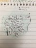
Storrolds2.jpg

Key:
Purple - Inlander settlements
Orange - Riverfolk + Coastal settlements.
Big purple/orange spludge - Ruddy Hall
Light blue - River
Blue line - fishtraps
Green thin lines - flood plain of the river
Big thick red line - end of project
Red dots - Proposed weirwoods
 
Last edited:

AerioOndos

Donkey Lord
Staff member
Pronouns
they/them
Also there is a minimodel of the project on my plot

Also, Iron and I have agreed to take on a steep roof thatch house Codd has designed. Its brilliant and on his plot at the moment.

This type of house would be used around the river and southern coast line
1604547456405.png
 
Last edited:
  • Like
Reactions: Mayflumes

otty

Sorcerer
Pronouns
she/her
Hey! So I know there isn't any documentation out yet officially on what I wanted for Beyond the Wall and that's totally on me however there were a few things I want to ensure that each project would follow to ensure consistency throughout Beyond the wall.

-Ensuring consistent terraforming methods and hopefully creating consistent terrain style.
-Ensuring a distinction between Northern builds and those BTW and creating a set of styles that can be built upon.
-Mapping the region to create proper borders
-Create a more concise base palette
-Outline regional "No-nos"
-Discuss appropriate settlement planning
-Create a canon document

- and a bit more

Right now what you're doing should be helping to set a high standard so much of that. I've begun to set the standard for terraforming in the mountains, however, you've got the coastline which I have no plan visually what those would appear to be. It would be beneficial if you created a method of coastline terraforming for this project that can be used for much of the eastern shoreline.

How about a map too? :D
6 settlements of a total of 64 homes seem extremely small. And you've not outlined any plan for further settlements other than "inland settlements". Maybe consider creating one to the best of your ability even if the terraforming may change?

Here is canon on the number of wildlings that are part of Mance's Raid and Camp. This kinda highlights why I'm a bit concerned about the number of settlements your intend to propose ^_^;. In the least, I would double it ... or more? Definitely, since this is the most densely populated.

"Mormont will not run, Jon thought. He is too old and he has come too far. He will strike and damn the numbers. One day soon he would hear the sound of warhorns, and see a column of riders pounding down on them with black cloaks flapping and cold steel in their hands. Three hundred men could not hope to kill a hundred times their number, of course, but Jon did not think they would need to. He need not slay a thousand, only one. Mance is all that keeps them together."

he fury of the wild, Jon thought as he listened to the skirl of skins, to the dogs barking and baying, the mammoths trumpeting, the free folk whistling and screaming, the giants roaring in the Old Tongue. Their drums echoed off the ice like rolling thunder.
He could feel the despair all around him. "There must be a hundred thousand," Satin wailed. "How can we stop so many?"

Jon saw men advancing on the Wall with bows and axes. Were there twenty or twenty thousand? In the dark, there was no way to tell.

though he would have balked at the notion of letting thirty or forty thousand wildlings loose on the Seven Kingdoms.

I just would really encourage fleshing out the lands more, creating a map, outlining the potential history, and really pre-planning this project! You seem to really care about having things be as accurate as possible and I think it would personally benefit you get that sorted out now. I don't want people to fuck up and follow in my footsteps of starting to import those elements half-way through because I only finally began to understand the wilding culture and the lands later on. As I know you're 100% aware these lands are unforgiving both in canon and in the building. Once you start developing it's nearly impossible to go back so, because of the bitch that is snow, spare yourself and create a more fleshed-out document. Really outline this culture, these lands, and this way of living on such rockier terrain. By creating a more detailed document will also help others who will be interested in other projects beyond the wall. This isn't just for you but it could really aid in projects bordering Storrolds and allow them to do appropriate transition work :D! Heck, I would even benefit from it aswell, now that you're giving me even more insight into their previous lifestyle.
I really want to see more and learn more about your plans! And I'm really glad fellow snow sufferers are joining me beyond the wall, and I am excited about the work you've presented already.

Oh, and the river needs a source for water but the mountains aren't really nearby how do you plan to create the water source? Hills maybe?

Here is the Canon doc to help!
Note that it's not finished, not in gather canon but in making it nice and neat. :p

https://docs.google.com/spreadsheets/d/1m71rqdg9kVeMAUYwFxqnTBt9GFMw2_JC6KSqNKNf9sU/edit?usp=sharing

Again sorry, please no hate. I just like this, am excite, and want to see more so we 3 can create an awesome start to the region. Thas all. K. Byeee! Best of luck!
 
Last edited:

AerioOndos

Donkey Lord
Staff member
Pronouns
they/them
Hey Otty, thanks for that.
I get what you’ve said and part of the lack of an expansive document is because of my own errors.
I have wrote up quite a bit of physical notes and then damaged them, was talking at length about them with IronGiant over the past month and I didn’t want to spend time typing them up because I am impatient to start building.

There is currently a model map on my plot at warp Aeksio which details locations, hills and then waterway. It also has some preemptive planning for Hardhome with the placement of a volcano at the tip of the peninsula.

The house number is reasonably small because the plan is to mostly have longhouses of some sort with two families at least in each. This would mostly be to conserve heat.

I will right up an extra culture attachment in an edit to this message or the original post that will hopefully clear up some of your points. (apologies for ignorance etc showing up in this post I've now corrected it but honestly the autocorrect on my phone is very very weird.
 
Last edited:
  • Like
Reactions: otty

AerioOndos

Donkey Lord
Staff member
Pronouns
they/them
*looks at pretty much finished meadhall test*
*looks at vikingcorgi's message*
*decides that another meadhall is needed in the project*

Okay so this is the Culture section.

There are roughly three groups. Inland, River and Coastal.

Inland people are out of sight of the sea and have homes built mostly of stone, sod and wood. These people live off seasonal foraging, hunting and some degree of migration when food stocks and herd numbers began to run low. They live on flatlands and somewhat in the low hills and rocky tumuli that stretch across the spine of the point. They used to burry their dead, now they burn them, as they are a continuation of or have been influenced by the BTW culture that created tombs around the Milkwater. These past tombbuilders built large piles of stones and earth over significant peoples' graves and some of these can be seen in the project, particularly closer to older settlements.
The Inland people also create earthen circular enclosures designed for herding elk into during leaner months so that they can have a captive herd. There might be one large enclosure shared by a whole village of large longhouses, which are shared by multiple families to conserve heat and fuel.
In short, Inlanders are identifiable by large, multi-family longhouses of sod, stone and wood, ringed earthen enclosures, areas for hanging and processing animal skins and tumulus grave mounds.

River people live along the streams and low lands of the project, mostly on the eastern side of the project. They use reeds cut from the waterway for roofing and have wooden walls. They build smaller dwellings than those of the Inlanders but have larger connected settlements, often with covered walkways between buildings.
They have steeper rooves than the other two groups. They, apart from being alongside rivers and streams, have nets, fish and eel traps and a series of tidal fishtraps near the rivers entrance. They have large fish drying infrastructure and preserve the fish for times ahead by smoking and drying. Outdoor communal areas are a particular feature where there would usually be a mixture of open fire cooking, story telling, and other activities.
In short, River folk have steep thatch rooves, large fishing infrastructure, covered walkways/connected structures and communal areas around which the houses are built.

Coastal folk are the crab worshippers. Their buildings are more often cut into the rocky coastline and have more obvious drainage features than the two other groups. They live in houses that sit partially below ground level, sometimes with interconnected 'streets' between buildings. These lowered paths are mostly 1-1.5 blocks deep but sometimes are 2 blocks deep. The houses are a mixture of roundhouses and oblong rounded houses and have walls packed with turf when not enclosed by stone or entirely dug into the ground. The structures are always in sight of the sea and similar to the river people, settlements have a connected feel to them because of the pathways (Similar to Scara Brae).
There will be seaweed harvesting facilities, fishing and crab netting. Some small scale boat making. Even some crab hunting in tidepools. Along with fish drying there will be baskets of crabs being broken open (red tile slab with half wattle fence around it). An altar will stand out near the waves with a sacrifice of crabs made to it. There will also be a large communal building in every one of these that will function as the temple. Where some blessings are given and received, as well as being a place of shelter and where some less important ceremonies are held by the medicine-men/woodswitches. In the largest settlement this will be an oblong hall.
What is worth noting is that they likely have the odd valuable good. Silks, dyed textiles, wine and precious metal foibles are all possible to find occasionally in their settlements as they come into contact with wrecks and the occasional trader from the Free Cities.
In short, Coastal folk are identifiable by their proximity to salt water, dug-in homes, places of worship and obsession with crabs.

Ruddy Hall is an interesting mix between the first two and the elements of the third.
It sits close to the river, some buildings have thatch rooves. However it has an earthen embankment around the settlement, for protection and to keep livestock in, and it functions as a welcoming trading point between the coast, river folk and the inland elk hunting wildling bands. Under Tormund's jovial protection, the meadhall saw plenty of use and fair trade was allowed, with some gentle taxing for golden armrings and... uh.... other rings, until the time Mance Rayder fought and won against the bearded king of Ruddy Hall.

Now most settlements lie abandoned with the pious crab-fondlers being worried of wight sightings to the south of them (if its reported that there are "Others on the shore near Eastwatch" to Jeor Mormont, surely the Wildlings have seen them too).
 
  • Like
Reactions: Thevikingcorgi

Scubooty

Bookbinder
Now this may be more for when the actual Hardhome build comes around. However, judging by what we have speculated about the mysterious ruination of hardhome it would be cool to see things along the shore showing signs of volcanic activity. Now I know Aeks you have mentioned black sand but I would like to recommend formations like the Giants Causeway in Ireland. Unfortunately, with current blocks its extremely difficult to show on a small scale however, Vanilla has the Basalt block which would be a perfect texture. Granted we don't want to go crazy adding unneeded textures but if it could be done with our current blocks I think it would be a cool addition to the shores to show signs of underwater volcanic activity.
 

AerioOndos

Donkey Lord
Staff member
Pronouns
they/them
Okay, this is outside of the project but yes, I was thinking of doing basalt formations. Because of the lack of lava/molten stone mentioned, I think there will have to be a herculaneum-like settlement on the other side of the volcano from Hardhome. I was also thinking of making basalt pillar coastal caves.
The current block mix I have in mind was volcanic stone for cooled lava and a Valyrian stone-Basalt cobble mix for the basalt pillars.
 

AerioOndos

Donkey Lord
Staff member
Pronouns
they/them
Hey powers that be, is there anything else that’s needs to be included in the application?
I’ve tried to detail what plotting of settlements will look like etc and will do somebody drawings quickly for examples but I wouldn’t really like hear something.
So far the response has been a reasonable one for a map of boundaries, someone eyeing off Otty’s map, Otty being really helpful and suggesting expansion of the application document and Scubooty suggesting landform details for the tip of the peninsula.

Also with volcanic parts, I don’t want to make the whole area volcanic stone and sand, only the northern half of the peninsula itself
 

CashBanks

A Knight at the Opera
Staff member
1605139662333.jpeg
Hey guys I’m ok with these plans, couple of queries before the greenlight
- Just to clarify, will Hardhome be a part of this project? Have you done any tests for it?

- A more detailed map showing the reterra area and the planned locations of the settlements would help a lot with getting a sense of the project's scale.

- If you end up nuking a big area of worldpainter terrain, use white wool as a placeholder block so it's not a big splodge on the dynmap plz.

- It looks like those house tests have exposed thatch rooves, this far beyond the Wall I think for consistency you will have to cover them completely in snow. Perhaps we need to consider a snow wall block to give you more options with the steep roof style.
 

AerioOndos

Donkey Lord
Staff member
Pronouns
they/them
Hi Cash,

On the first point, no we are not doing Hardhome as part of the app, instead focusing on the area between the wall and the lower half of the peninsula.

I can rig together a better map of the reterra area. Mostly it is rerouting and updating the river.

I built tests without snow to begin with, then applied it to the structure or not at all in the case of the Ruddy Hall. The thatch steep rooves that Codd made are steep enough that snow will not build up on the sides and internal heat would melt any that did stick. I al planning for the river settlements that showcase these to have been recently abandoned and so they still have reasonably warm interior temperatures (<10° rather than -10°.
I was also betting on getting thatch underside snow stairs for the project. If absolutely necessary the style can be dropped and the Scarabrae style pictured up for river people too.
 

AerioOndos

Donkey Lord
Staff member
Pronouns
they/them
As I have said before there is a mini map on my plot but it is not the most clear and obvious map. I will rig together a more effective one on Sunday evening after I return home. It will be a recreation of a handdrawn map I have shown to Irongiant before and he has okayed
 
  • Like
Reactions: Scubooty