Hi guys and girls, Ive seen the detail going into this build and having spent many years studying geomorphology and thought you might find a basic guide to Rivers useful? There are of course many intricacies, so this is just the broad brushstrokes.
Lets start with how water gets overland to a river, it called overland flow, eventually flow congregates to a lower point becoming a rill, then a gulley/stream. Some water goes into the ground, and flows through the surface. When this gets forced to the surface you get a spring, or if its in the bottom of a dip/valley a permenant river. Every significant lowpoint in a surface will have a watercourse, be it permenant or ephemeral (seasonal with the rain). Also remember that all wet vallys should have a river, bit the river may not have created the valley in which it flows, techtonics and glaciation can do that.
Now for generic riveryness before moving on to more specific features.
First a rivers long profile is key.
http://www.geography.learnontheinternet.co.uk/images/rivers/LongProfile.png
The upper course is the steep section down the mountainside. High energy bit small streams that can move large boulders at high flow (with the assistance of gravity). Think waterfalls and pools bouncing down a hillside.
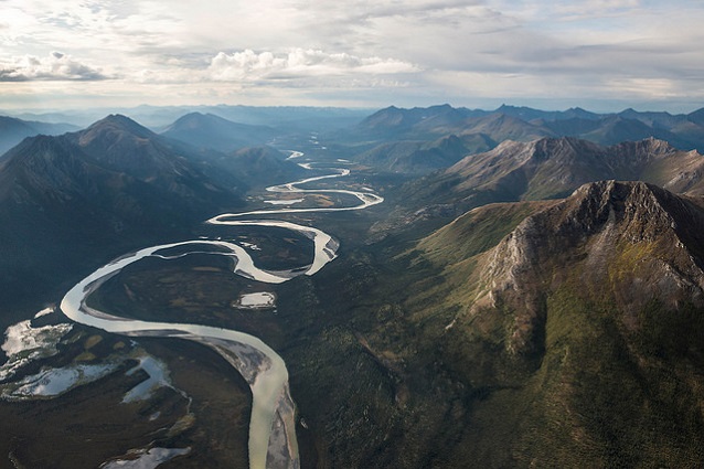
The middle course is where the river profile curves in the mountain piedmont. Here rivers tend to run through pools and riffles (rapids) as it 'steps' down. Its course will be generally straight with a bit of sinuosity. It is also loosing its carrying capacity so we are now looking at cobbles pebbles and gravel as it starts to deposit material larger stuff first.
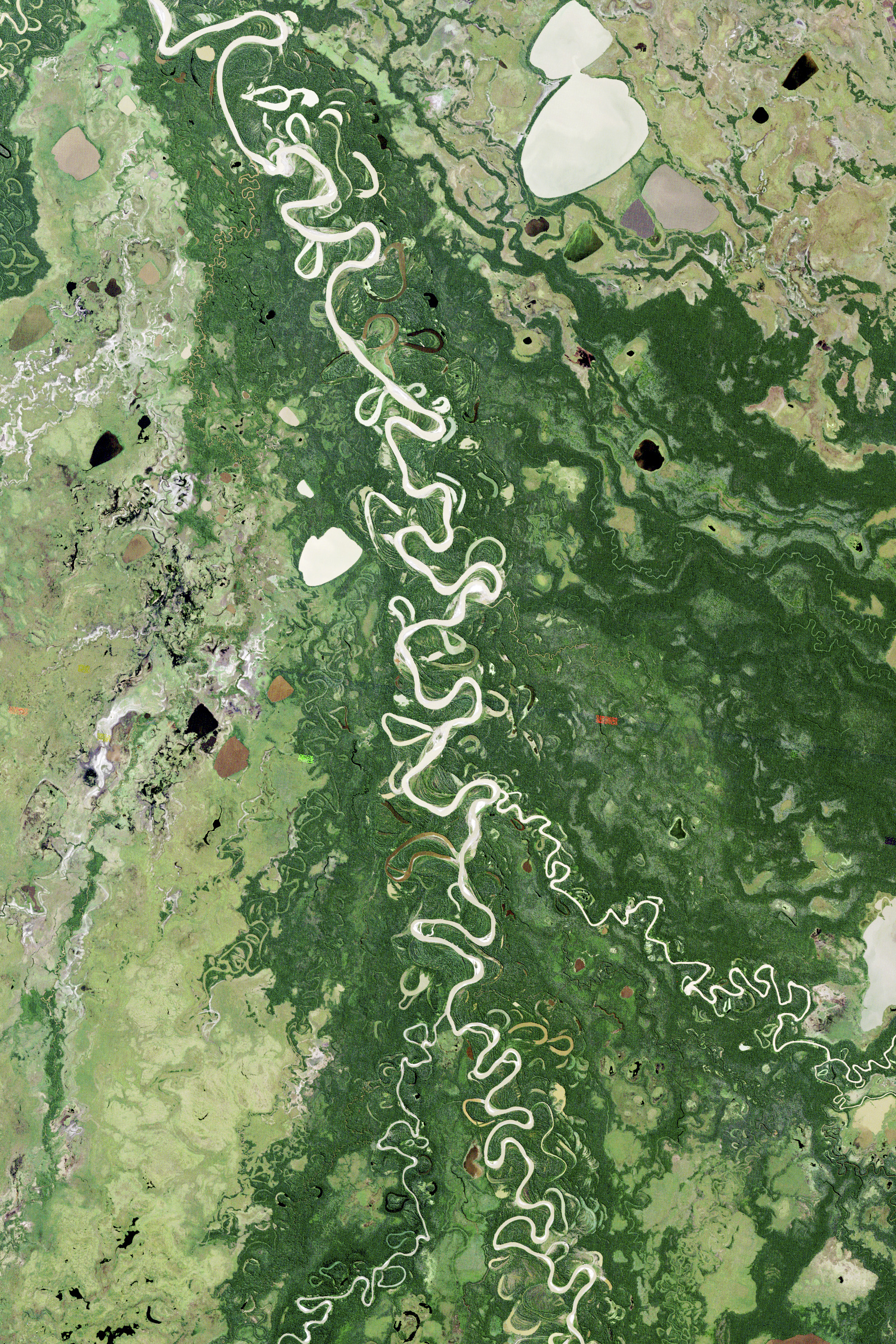
In the lower course the profile tends towards infinitesimal flatness. Here is where we get meanders. By now the river has dropped its heavy material and is carrying just silt and sand. This means it has some excess energy which it can use to erode laterally. Looking back at the long profile this winding lengthens the lower course and so shallows the gradient, helping the river move towards that perfect curve.
The river mouth, where it flows into a larger body of water, (sea, lake, a bigger river, groundwater)
This profile can re occur (in part or in full) several times over a rivers full course. Think, underlying terrain stepping down, base level change. So the big long profile gets made up of several smaller ones. You can also look at the actual landscape and profile compared to the ideal curve to see where a river should be eroding downwards (steep gradient) lateraly (shallow gradient) or depositing (when its below the ideal curve)
On to features.
Meanders
Everybodys favourite bendy river bit. As mentioned above these tend to occur in the lower reaches of a river where several factors combine; to start with excess energy allows them to erode sideways, but we also need to look at if the land it flows over is soft and easily eroded, and flat and wide, or confined at all, to determine how much a river can meander. Less energy and harder to erode is more static, more energy and easier to erode leads to oxbow lakes and palimpsest (overwritten) landscapes. The key for the latter is remembering that once a river has broken through and found a shorter course it will follow it and abandon the old one leaving a lake or dry scar, unless it was a recent high flow occurrence on a hard to erode surface in which case the new cut will be a dry scar.
Braided river channels.
Two main causes for this. The first is seasonal instability, bars (banks of deposited material) stick out during low flow and get re submerged at high flow. If low flow is the norm then more material can build up around the bars, turning them into more permanent islands, after enough time stabilising plants will grow. The second cause is in stable flowed mountain rivers as they enter the piedmont (middle course) the change in gradient leaves the river unable to carry its larger material and this gets deposited en masse, again causing splits and joins of river in a wider channel scar.
Deltas
These occur when a river discharges into a larger body of water such as the sea or a lake. Here the flow spreads and slows, causing it to drop its sediment. If the body of water is shallow, calm (enough to not be too erosive) and river flow not too fast/ sediment level nice and high, then these deposits build up causing the river to split up into many distributry channels.
Fans like those in death valley are a similar principle where steep mountain rivers spread onto a wide flat valley floor.
Lakes.
A big pool of water caused by one of several reasons. A geological dip in the terrain that gets filled up until the water flows out through the lowest point in the surrounding terrain. A dam/weir blocking the water, this can be natural where fans/ glacial deposits, landslides etc block a valley. Another way to back water up is by restricting flow by a narrowing of impermeable hard to erode terrain, if inflow is grater than what can get through then the water will back up to form a lake. In general there will only be one lake outlet channel, its possible for several similarly low points to form several channels, with inflow keeping levels high enough to maintain them, but thos is an unstable situation, when one erodes lower than the others it will dominate and eventually become the sole outlet. I tried to find an example of a multi outlet channel but couldnt.
Canyons and deep valleys.
Two main causes. A lake has built up flowed over a low point and rapidly eroded a straightish deep channel (ie afton canyon california). The second more often seen is where a meandering river on a flat plain starts to erode downwards because the level of what it flows into has lowered.
Finally a word on flow state. When rivers flow high its because there is an ample source of water, so look at what your rivers source is. Glacial flow peaks in late summer where the melt is highest, mountain snow melt in the spring as it heats up but before all the snow is gone. Temperate rivers flow highest in winter rains, desert ephemeral streams just after a thunder storm as a flash flood, and tropical rivers flow highest in summer when the sun is overhead creating the biggest storms.
The key is to look at the land your river flows over and the source of its water to work out what it will do and where.
Hope this pasted in ok, feel free to shoot me any questions.