Presented by the GentleIrongiant, better known as
PeanutGuy
Resume: Uffering Holdfast 2, Knott Holdfast,
Project Co-Lead on Norrey, Rousemont Quarry and Hamlet, Previous Project Co-Lead on Darkdell,
Medieval Industry & Siege Warfare Expertise
House Norcross is a noble house from the Reach. According to semi-canon sources, they blazon their shield with a cross embattled, black on white.
Ser Jeffory Norcross, known as Neveryield, was a member of the Kingsguard. – A Feast for Crows
Ser Hosman Norcross was a household knight in service to Ser Colin Florent when he received an offer to marry Colin’s daughter, Delena Her father had already declined a match with Tyrion Lannister who had been offered only after Delena was deflowered by King Robert I Baratheon in the wedding bed of her cousin, Selyse, and his brother, Stannis. The result of that union was Edric Storm. – A Game of Thrones, A Clash of Kings, A Storm of Swords
Ser Bayard Norcross (not known what relation he has to the current Norcross Lord) is among the household knights who spend time with Queen Margaery Tyrell. Queen Cersei Lannister has an arrest warrant signed for Bayard as part of her plan to get rid of Margaery. He is sent to the dungeons of the Red Keep after his arrest. – A Feast for Crows
(Some interest of note is that the current Grandmaster of the Teutonic Order has the ser name Bayard)
Ser Tyler Norcross was a knight and head of House Norcross during the civil war known as the Dance of Dragons. He was a part of the Caltrops, a group of 13 Nobles from the Reach who plotted to kill the Two Betrayers during the Dance of Dragons. Except for 3 Caltrops, he and the others were all killed during the Second Battle of Tumbleton. – Fire & Blood, The Princess and the Queen
The Plan
- 1. Norcross Keep (and Castle) will be modeled after Chateau de Falaise – translated as Cliff Castle or Castle of the Cliffs. The keep as with Falaise will feature a Great Donjon, a petite Donjon, and a large signal tower. The signal tower beacon will not be lit as it is used to signal an Ironborn Landing. The southern wall or pasture wall will have three towers and a gatehouse, with the western tower being a beacon tower. It will rise a few meters above a shallow ditch. The northern wall or cliffside wall will be lower in height than the southern wall. The yard will either feature a few siege weapons or a fortified sept, separate kitchen, stables, and a blacksmith.
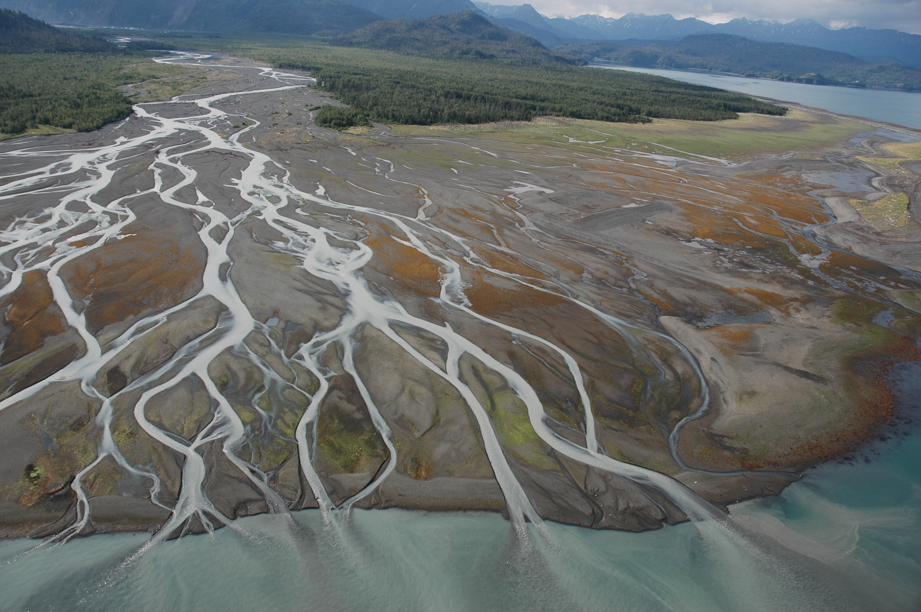
- 2. The Mander Bay - I read somewhere and I believe it canon that the mouth of the Mander is a Bay rather than a series of sandbars at low tide. I like the sandbars layout, but think there should be a bay, so I think it best to submerge the masses of sandbars under the water. Alternatively, some at the edge of the bay could stay (though made slightly smaller in size) and the rest could be elmiminated.
- 3. Norcross Town has a wharf that rest 2-3 meters above the bay with a small creek entering the bay through the center of town. The creek has various headwaters from the cliff hills to the south and there are times when the creek floods causing damage to the houses in the center of town, with a few being abandoned occasionally. The industry of the town is located on higher ground, while there is evidence of construction efforts to raise the lower sections around the creek to help prevent flooding. The main thoroughfare of the town is located on the road leading along the cliffside up to the castle gatehouse. It has a small gatehouse entrance and a mixture of stone and timber framed houses lining the road up to the castle entrance. For inspiration I’ll be using the town of Chateau de Rocamadour. The town will consist of less than 20 plots, mostly middle low-class with a few middle-class plots. Among those are possibly a sailor’s tavern and an inn.
- 4. Norcross Fishing Co., Salt Storage & Drying Complex – The town has a wayside wharf used by their own Fishing Company (currently numbering 3 vessels) and other Merchant companies. The little bay town’s main commodity is “Sunset Cod” of which only a few Houses know where to get. The Cod is dried on land at the complex, where sea salt bought from Uffering is stored. Salt is then sold to various trade and fishing vessels transiting the Mander River. Sales of Cod bring in much revenue for the Norcross. Once caught far out in an unknown region of the Sunset Sea, the Cod is salted and then brought to be dried. After drying, it is put on barges and shipped upriver to various market towns including HighGarden. The wharf/harbor may feature 2 or 3 harbor towers based on the La Rochelle Harbor Towers and used to direct ships as they close in on the harbor.
- 5. The Lagoon is to be razed and the land then raised between 10 meters in the West to 5 meters in the East with a Limestone Bluff extending along the southern side of the Mander until it bends south near Castle Ball. It’ll be like the Bluff on the Eastern shore of the Mobile Bay in Alabama. On the created plateau will be a large farmland consisting of wheat, barley, buckwheat, etcetera. A shallow ravine will flow through the center of what once was the Lagoon. The south of the ravine will feed a reservoir that powers the local grain mill. The mill hamlet will consist of 7 low class farmhouses and a barn.
- 6. Island Hillfort – The Bluff will extend near an island in the Mander. The Island holds a First Men Hillfort repurposed with modern Reach fortifications to act as a holdfast and/or rendezvous point for local Reach forces to gather in the event of an Ironborn raid. The Hillfort will feature a signal tower. On the mainland there is a small hamlet of 5 low class farmhouses and a fortified grain mill that connects to a dyke and wooden gatehouse around the hamlet. To the south of the hamlet and just before the covered bridge will be a series of abandoned and ruined stone houses from a long since past Ironborn raid.
- 7. Land Sold to Liege Lord Florent – The land down south was sold by a past Lord Norcross to their Liege Lord, a past Florent, and that Lord Norcross used the money from that land sale to build up Norcross’s current commercial endeavors.
- 8. The Forest, Cliff Hills of the South, and Shipbuilders – The forest interior of Norcros is heavy with thick undergrowth (dark green), except for the exterior where though still heavy, much of the undergrowth is sparse or nonexistent (light green). In the western part on top of some of the cliff hills, trees have begun to be felled for shipbuilding at Oldtown, the Arbor, the Shield Isles, or any other port cities in Westeros that specialized in shipbuilding and want strong timbers. Why is the timber strong? Cause trees that are located on the edge of a forest especially a cliff hill facing a coast generally receive stronger winds than trees further within the forest. For this reason, they are usually the strongest and sturdiest of timbers, making them prize material for shipbuilding. The current Lord Norcross has rented out 2 portions of the Forest to shipbuilding companies from the Arbor and Oldtown.
- 9. Martello Towers of Ireland – The coastal beacons are an optional idea, though I may consider not building them as my inspirations are from the 19th century Martello Towers of Ireland.
- 10. The Castle Plateau and Cow Pastures – The castle plateau is tall in the North where the castle sits on a cliffside 25 meters above the Bay. The ditch is roughly 5 meters below the pasture wall. From there the land has a series of shallow ditches and banks until it reaches the cliff hills in the south just before the Bandalon Road. The land is largely used for livestock grazing, as well as the coastal lands along the Bandalon road.
- Alternative Idea for Keep – If the current plans seem to bold or too powerful for Norcross, then I may do away with the castle walls, towers, and gatehouse in their finished phase. Instead, I’ll have them in either a phase of construction or just entirely non-existent.
Tests at /warp IronGiant (top level)
The Norcross Castle
I’ll be using the Chateau de Falaise for inspiration. Below is a video of a virtual reconstruction of Falaise, from which I will focus on the Donjon of the castle from 1160 to 1250. I think I may add the hypothetical third level which is thought to have been destroyed supposedly by cannons in the 1500s.
Chateau de Falaise 3d Reconstruction
Exterior and Interior
Norcross Town
For inspiration, I’ll be using the town of Chateau de Rocamadour which winds through a series of gatehouse checkpoints around a cliffside up to the top of a plateau.
Rocamadour Screenshots
Norcross Wharf (Harbor)
For the wayside wharf, which I want to show as partially being under construction, I’ll be using some stuff from Wikipedia and other places, along with my industry expertise.
https://en.wikipedia.org/wiki/Fresh_Wharf
https://en.wikipedia.org/wiki/Revetment
https://en.wikipedia.org/wiki/Riprap
https://en.wikipedia.org/wiki/Revetment
https://en.wikipedia.org/wiki/Riprap
Terrain & Schems
I’ve talked to Ark about this and from what he said I think it is fine to do. For the terrain I want to keep it somewhat like the lands of Woodwright to the East and on the southern side of the Mander. I think I’ll expand this into Norcross with a few minor variations. The minor variations would be making the lands a bit stonier due to the bluffs I’ve imagined being in the area. Along the proposed Mander Bay, it’s been suggested that I incorporate some fair-sized bay shores. I may need some help with creating schems or tests when it comes to making the minor variations.