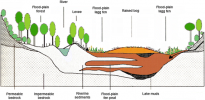
Hey all! Been awhile since I've made one of these. Today we'll be looking at good hydrology. Hydrology refers to the study of how water moves basically. This includes rivers, groundwater and rain.
So, to start this off, I'll talk a little bit about the water cycle. The water cycle is a constant process where water goes from the ground into the atmosphere and then the ground again. With the help of this diagram, I'll explain a little bit more.
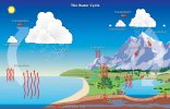
We'll start with evaporation. Surface water if evaporated, when the sun heats it up, and it becomes a vapour. As it slowly rises, the water vapour then condenses into clouds. As those clouds move, they acquire more and more water, which eventually falls to the ground in the form of rain, sleet or snow. This is precipitation. Significant amounts of precipitation may cause rivers and lakes to flood, and burst their banks. While rainwater alone cannot create a river, as it collects underground into a spring this eventually becomes enough to form a river. Water that seeps into the ground is - you guessed it - groundwater. This is used by plants and trees. The plants undergo a process called transpiration, which is long and boring so I won't explain it much. Basically, water from the tree or plant gets evaporated from the leaves or stems. Another important thing to note is snow. Runoff from snowy mountains can create small streams, or feed other rivers in the area. So when it gets hotter, these streams would most likely grow in size due to the extra water from the snowmelt.
Lakes typically form when you have a basin that gets enough water collecting there that it eventually fills. If the water has nowhere to travel, it stays in the basin. However, if there is an opening in the basin for water to flow through, then you'll get a stream partially draining the lake. Water from lakes and rivers seep into the ground, where we find the water table. The water table is essentially the depth where the ground is saturated with water. In areas with permeable soil and sufficient rainfall, the water table may slope down to meet rivers, as the water drains from the water table into the river or lake.
This is all well and good, but not really applicable to the server. I just wanted to clear up some reasons why rivers and lakes form. Next, I'll talk a bit about watersheds. A watershed is defined as an area where precipitation drains into.
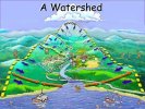
This demonstrates how water is brought into lower land due to gravity. Water always takes the easiest path, so if confronted with obstacles like a boulder, a river will go around them through more permeable soil. Rivers will never turn away from a downward slope. The closest decline in terrain will be where the water drains. You may be thinking "Jake, how do we show this in minecraft?"
Well, inquisitive builders, here are some examples of good hydrology on the server that reflect the concepts spoken about here.
Firstly, Rhysling does a great job of demonstrating rivers and watersheds. Kulmen has done a great job of making cutbanks, braided rivers and meanders. In this screenshot, we can see 4 streams travelling down quite steep terrain. They join together and form a braided river. The reason this river is braided, is because it has a height change of about 10 blocks over a distance of 300-400 blocks. While it may not look very steep in game, in real life, this is a significant height change, which is enough to warrant braiding. If there were changes in rock type here, we may see rapids form instead. They typically form on steeper slopes when a river goes through soft rock, meets hard rock and can't erode through it, so the water goes around or over it back through soft rock. For a good example of rapids see below.
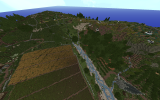
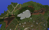
Kul also does a great job of showing lake drainage. This image shows a lake that is fed by a stream (and presumably groundwater), which then is drained by a stream.
Next example: Starpike! Starpike has really nice rapids, which show where the soft rock has been cut away and the denser rock causes pools to form until the water rises over it and carries on down the mountain.
Varner does a nice job of making meanders. Meanders are basically rivers that are windy. One of the drawbacks with my previous river tutorial, is that there were no cutbanks, and no evidence of sediment deposition on the inner corners of meanders. If you check out Varner now, you can see on the outside of the river bends, the bank is smaller, and the inner bends have wet sand and larger banks. I've also included a little fenland or a carr. A fen is a frequently flooded area of flat land, usually dominated by sedges and reeds. Fens are peat-forming wetlands, which means as plant matter decays, it becomes a substance known as peat. Peat is typically quite dark brown in colour. Other peat-accumulating wetlands are bogs, which are also known as mires. The difference between a fen and a bog is that a fen usually has trees like Alders, buckthorns and other water-loving plants. A bog has peat as well as types of moss (usually sphagnum moss). This means the ground is too spongy for trees to grow. Bogs have quite low biodiversity as a result. A carr refers to a fenland that is drained. Carrs support more shrubs than trees, as they are still quite waterlogged.
Of course, these aren't the only examples of good hydrology, these are just the ones I could be bothered to do before I wanted to get this post finished
If you have any questions or comments please feel free to let me know and I'll try to cover it!
So, to start this off, I'll talk a little bit about the water cycle. The water cycle is a constant process where water goes from the ground into the atmosphere and then the ground again. With the help of this diagram, I'll explain a little bit more.

We'll start with evaporation. Surface water if evaporated, when the sun heats it up, and it becomes a vapour. As it slowly rises, the water vapour then condenses into clouds. As those clouds move, they acquire more and more water, which eventually falls to the ground in the form of rain, sleet or snow. This is precipitation. Significant amounts of precipitation may cause rivers and lakes to flood, and burst their banks. While rainwater alone cannot create a river, as it collects underground into a spring this eventually becomes enough to form a river. Water that seeps into the ground is - you guessed it - groundwater. This is used by plants and trees. The plants undergo a process called transpiration, which is long and boring so I won't explain it much. Basically, water from the tree or plant gets evaporated from the leaves or stems. Another important thing to note is snow. Runoff from snowy mountains can create small streams, or feed other rivers in the area. So when it gets hotter, these streams would most likely grow in size due to the extra water from the snowmelt.
Lakes typically form when you have a basin that gets enough water collecting there that it eventually fills. If the water has nowhere to travel, it stays in the basin. However, if there is an opening in the basin for water to flow through, then you'll get a stream partially draining the lake. Water from lakes and rivers seep into the ground, where we find the water table. The water table is essentially the depth where the ground is saturated with water. In areas with permeable soil and sufficient rainfall, the water table may slope down to meet rivers, as the water drains from the water table into the river or lake.
This is all well and good, but not really applicable to the server. I just wanted to clear up some reasons why rivers and lakes form. Next, I'll talk a bit about watersheds. A watershed is defined as an area where precipitation drains into.

This demonstrates how water is brought into lower land due to gravity. Water always takes the easiest path, so if confronted with obstacles like a boulder, a river will go around them through more permeable soil. Rivers will never turn away from a downward slope. The closest decline in terrain will be where the water drains. You may be thinking "Jake, how do we show this in minecraft?"
Well, inquisitive builders, here are some examples of good hydrology on the server that reflect the concepts spoken about here.
Firstly, Rhysling does a great job of demonstrating rivers and watersheds. Kulmen has done a great job of making cutbanks, braided rivers and meanders. In this screenshot, we can see 4 streams travelling down quite steep terrain. They join together and form a braided river. The reason this river is braided, is because it has a height change of about 10 blocks over a distance of 300-400 blocks. While it may not look very steep in game, in real life, this is a significant height change, which is enough to warrant braiding. If there were changes in rock type here, we may see rapids form instead. They typically form on steeper slopes when a river goes through soft rock, meets hard rock and can't erode through it, so the water goes around or over it back through soft rock. For a good example of rapids see below.

Kul also does a great job of showing lake drainage. This image shows a lake that is fed by a stream (and presumably groundwater), which then is drained by a stream.

Next example: Starpike! Starpike has really nice rapids, which show where the soft rock has been cut away and the denser rock causes pools to form until the water rises over it and carries on down the mountain.
Varner does a nice job of making meanders. Meanders are basically rivers that are windy. One of the drawbacks with my previous river tutorial, is that there were no cutbanks, and no evidence of sediment deposition on the inner corners of meanders. If you check out Varner now, you can see on the outside of the river bends, the bank is smaller, and the inner bends have wet sand and larger banks. I've also included a little fenland or a carr. A fen is a frequently flooded area of flat land, usually dominated by sedges and reeds. Fens are peat-forming wetlands, which means as plant matter decays, it becomes a substance known as peat. Peat is typically quite dark brown in colour. Other peat-accumulating wetlands are bogs, which are also known as mires. The difference between a fen and a bog is that a fen usually has trees like Alders, buckthorns and other water-loving plants. A bog has peat as well as types of moss (usually sphagnum moss). This means the ground is too spongy for trees to grow. Bogs have quite low biodiversity as a result. A carr refers to a fenland that is drained. Carrs support more shrubs than trees, as they are still quite waterlogged.
Of course, these aren't the only examples of good hydrology, these are just the ones I could be bothered to do before I wanted to get this post finished
If you have any questions or comments please feel free to let me know and I'll try to cover it!


