Geomorphology 101
1. Fluvial Processes
- A story of friendship between flowing water and sediment-
------------------------------------------------------------------------------------------
DISCLAIMER:
I'm going to copy/paste this together from various sources, primarily wikipedia. Sources will be cited in the text. You're very welcome to spot errors and contribute. Get a mod to edit this post! I am not formally trained in any of this, so don't become a geologist based on the information I provide here.
------------------------------------------------------------------------------------------
1. The Water Cycle
To illustrate briefly where water on the land comes from it is important to understand the water cycle!

(Source: https://en.wikipedia.org/wiki/Water_cycle)
1.1 Thalweg
The thalweg is a line drawn to join the lowest points along the entire length of a stream bed or valley in its downward slope, defining its deepest channel. The thalweg thus marks the natural direction (the profile) of a watercourse. (Source: https://en.wikipedia.org/wiki/Thalweg)
In other words: The thalweg is pretty much the line in a valley where surface water collects. That means the thalweg is the most likely position of a stream!
Not suprisingly, once you have a stream in a valley the thalweg will automatically be the deepest part of the river.
In fairly straight streams, the thalweg is near the middle of the channel, while in very bendy streams it alternates from one bank to the other.
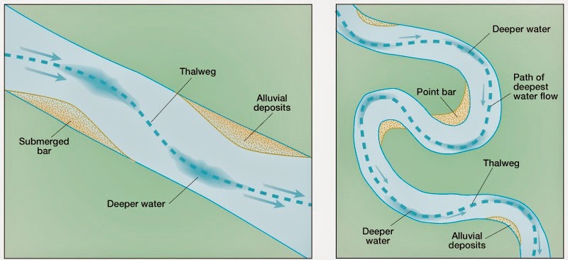
(Source: http://aerialgeologist.blogspot.dk/2015/04/thawing-thalweg.html)
1.2. Open Drainage Basins ('catchment area')
So from the Water Cycle and the Thalweg principle we know that surface water caused by precipitation will collect in the lowest parts of the terrain. So, a drainage basin or 'catchment area' is any area of land where precipitation collects and drains off into a common outlet, such as into a river, bay, or other body of water. The drainage basin includes all the surface water from rain runoff, snowmelt, and nearby streams that run downslope towards the shared outlet, as well as the groundwater underneath the earth's surface. (Source: https://en.wikipedia.org/wiki/Drainage_basin)
Drainage areas are separated by drainage divides (brit. engl. "watersheds"), which are often higher or water-impregnable land masses like ridges or hills but can also be subsurface rock strata or even on a valley floor. Fun fact: Some Swiss towns are erected at valley floor drainage divides with "Eben im Pongau" being a nice example where this phenomenon is even displayed in the coat of arms: https://de.wikipedia.org/wiki/Eben_im_Pongau
Here you can see the capital drainage basins of Europe. Note that the principal river within them is the body of water that almost all of the smaller streams drain into! The principal streams then drain into the ocean.

(Source: https://en.wikipedia.org/wiki/Drainage_divide)
The most common drainage pattern is 'dendritic' i.e. branched like a tree, which means that several smaller streams converge into one large one:

(Source: http://web.gccaz.edu/~lnewman/gph111/topic_units/fluvial/fluvial2.html)
But it is important to note that there are many different patterns which depend strongly on the local topography!

(Source: https://mwsu.edu/Assets/documents/s...-1134/Supplement-Streams,-Water,-Surfaces.pdf)

(Source: http://geologycafe.com/images/drainages.jpg)
The water output of an entire drainage system also strongly depends on the type of soil. Sandy soils = water will be absorbed into the ground until a certain limit is reached, soils consisting of clays or bedrock = water will stay on the surface and contribute in great volumes to the drainage outflow, each stronger rainfall here may contribute to intermittent floods.
1.3. Closed Drainage Basins ('endorheic basins')
Source mostly https://en.wikipedia.org/wiki/Endorheic_basin
An endorheic basin is a closed drainage basin that normally retains water and allows no outflow to other external bodies of water, such as rivers or oceans, but converges instead into lakes or swamps, permanent or seasonal, that equilibrate through evaporation. In the past century or so, many very large endorheic lakes have been reduced to small remnants of their former size, as with the Aral Sea, Lake Chad and Lake Urmia, or gone completely as have Tulare Lake and Fucine Lake.

Endorheic regions can occur in any climate but are most commonly found in desert locations. In areas where rainfall is higher, riparian erosion will generally carve drainage channels (particularly in times of flood), or cause the water level in the terminal lake to rise until it finds an outlet, breaking the enclosed endorheic hydrological system's geographical barrier and opening it to the surrounding terrain. The Black Sea was likely such a lake, having once been an independent hydrological system before the Mediterranean Sea broke through the terrain separating the two. Lake Bonneville was another such lake, overflowing its basin in the Bonneville flood.
Examples of relatively humid regions in endorheic basins often exist at high elevation. These regions tend to be marshy and are subject to substantial flooding in wet years. The area containing Mexico City is one such case, with annual precipitation of 850 mm and characterized by waterlogged soils that require draining.[4]
Endorheic regions tend to be far inland with their boundaries defined by mountains or other geological features that block their access to oceans. Since the inflowing water can evacuate only through seepage or evaporation, dried minerals or other products collect in the basin, eventually making the water saline and also making the basin vulnerable to pollution. Approximately 18 percent of the earth's land drains to endorheic lakes or seas, the largest of these land areas being the interior of Asia.
Closed water flow areas often lead to the concentration of salts and other minerals in the basin. Minerals leached from the surrounding rocks are deposited in the basin, and left behind when the water evaporates. Thus endorheic basins often contain extensive salt pans (also called salt flats, salt lakes, alkali flats, dry lake beds or playas).

(Source: https://en.wikipedia.org/wiki/Okavango_Delta)
Above you can see my favourite endorheic basin: The Kalahari Desert Basin with its main tributary being the Okavango River. Below, in the uppers center of the image, you can see the surreal but very real billions of litres of water just literally spilling into the desert.

1. Fluvial Processes
- A story of friendship between flowing water and sediment-
DISCLAIMER:
I'm going to copy/paste this together from various sources, primarily wikipedia. Sources will be cited in the text. You're very welcome to spot errors and contribute. Get a mod to edit this post! I am not formally trained in any of this, so don't become a geologist based on the information I provide here.
1. The Water Cycle
To illustrate briefly where water on the land comes from it is important to understand the water cycle!

(Source: https://en.wikipedia.org/wiki/Water_cycle)
1.1 Thalweg
The thalweg is a line drawn to join the lowest points along the entire length of a stream bed or valley in its downward slope, defining its deepest channel. The thalweg thus marks the natural direction (the profile) of a watercourse. (Source: https://en.wikipedia.org/wiki/Thalweg)
In other words: The thalweg is pretty much the line in a valley where surface water collects. That means the thalweg is the most likely position of a stream!
Not suprisingly, once you have a stream in a valley the thalweg will automatically be the deepest part of the river.
In fairly straight streams, the thalweg is near the middle of the channel, while in very bendy streams it alternates from one bank to the other.

(Source: http://aerialgeologist.blogspot.dk/2015/04/thawing-thalweg.html)
1.2. Open Drainage Basins ('catchment area')
So from the Water Cycle and the Thalweg principle we know that surface water caused by precipitation will collect in the lowest parts of the terrain. So, a drainage basin or 'catchment area' is any area of land where precipitation collects and drains off into a common outlet, such as into a river, bay, or other body of water. The drainage basin includes all the surface water from rain runoff, snowmelt, and nearby streams that run downslope towards the shared outlet, as well as the groundwater underneath the earth's surface. (Source: https://en.wikipedia.org/wiki/Drainage_basin)
Drainage areas are separated by drainage divides (brit. engl. "watersheds"), which are often higher or water-impregnable land masses like ridges or hills but can also be subsurface rock strata or even on a valley floor. Fun fact: Some Swiss towns are erected at valley floor drainage divides with "Eben im Pongau" being a nice example where this phenomenon is even displayed in the coat of arms: https://de.wikipedia.org/wiki/Eben_im_Pongau
Here you can see the capital drainage basins of Europe. Note that the principal river within them is the body of water that almost all of the smaller streams drain into! The principal streams then drain into the ocean.

(Source: https://en.wikipedia.org/wiki/Drainage_divide)
The most common drainage pattern is 'dendritic' i.e. branched like a tree, which means that several smaller streams converge into one large one:

(Source: http://web.gccaz.edu/~lnewman/gph111/topic_units/fluvial/fluvial2.html)
But it is important to note that there are many different patterns which depend strongly on the local topography!

(Source: https://mwsu.edu/Assets/documents/s...-1134/Supplement-Streams,-Water,-Surfaces.pdf)

(Source: http://geologycafe.com/images/drainages.jpg)
The water output of an entire drainage system also strongly depends on the type of soil. Sandy soils = water will be absorbed into the ground until a certain limit is reached, soils consisting of clays or bedrock = water will stay on the surface and contribute in great volumes to the drainage outflow, each stronger rainfall here may contribute to intermittent floods.
1.3. Closed Drainage Basins ('endorheic basins')
Source mostly https://en.wikipedia.org/wiki/Endorheic_basin
An endorheic basin is a closed drainage basin that normally retains water and allows no outflow to other external bodies of water, such as rivers or oceans, but converges instead into lakes or swamps, permanent or seasonal, that equilibrate through evaporation. In the past century or so, many very large endorheic lakes have been reduced to small remnants of their former size, as with the Aral Sea, Lake Chad and Lake Urmia, or gone completely as have Tulare Lake and Fucine Lake.

Endorheic regions can occur in any climate but are most commonly found in desert locations. In areas where rainfall is higher, riparian erosion will generally carve drainage channels (particularly in times of flood), or cause the water level in the terminal lake to rise until it finds an outlet, breaking the enclosed endorheic hydrological system's geographical barrier and opening it to the surrounding terrain. The Black Sea was likely such a lake, having once been an independent hydrological system before the Mediterranean Sea broke through the terrain separating the two. Lake Bonneville was another such lake, overflowing its basin in the Bonneville flood.
Examples of relatively humid regions in endorheic basins often exist at high elevation. These regions tend to be marshy and are subject to substantial flooding in wet years. The area containing Mexico City is one such case, with annual precipitation of 850 mm and characterized by waterlogged soils that require draining.[4]
Endorheic regions tend to be far inland with their boundaries defined by mountains or other geological features that block their access to oceans. Since the inflowing water can evacuate only through seepage or evaporation, dried minerals or other products collect in the basin, eventually making the water saline and also making the basin vulnerable to pollution. Approximately 18 percent of the earth's land drains to endorheic lakes or seas, the largest of these land areas being the interior of Asia.
Closed water flow areas often lead to the concentration of salts and other minerals in the basin. Minerals leached from the surrounding rocks are deposited in the basin, and left behind when the water evaporates. Thus endorheic basins often contain extensive salt pans (also called salt flats, salt lakes, alkali flats, dry lake beds or playas).

(Source: https://en.wikipedia.org/wiki/Okavango_Delta)
Above you can see my favourite endorheic basin: The Kalahari Desert Basin with its main tributary being the Okavango River. Below, in the uppers center of the image, you can see the surreal but very real billions of litres of water just literally spilling into the desert.

Last edited:


